Wauneta geodata
Wauneta (Nebraska) is a populated place; located in United States in America/Denver (GMT-6) time zone. With population of 574 people, there are 19987 cities with bigger population in this country. Compared to other cities in United States, 58.1% of cities are located further ↓South; 81.5% of cities are located further →East and 92.7% of cities have lower elevation than Wauneta. Note1


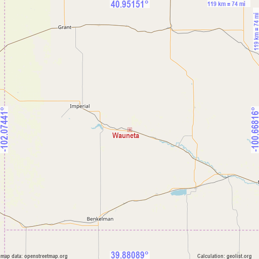
Wauneta GPS coordinates[2]
40° 25' 5.988" North, 101° 22' 16.608" West
| Map corner | latitude | longitude |
|---|---|---|
| Upper-left | 40.95151°, | -102.07441° |
| Center: | 40.41833°, | -101.37128° |
| Lower-right: | 39.88089°, | -100.66816° |
| Map W x H: | 119×119 km | = 73.9×73.9mi |
| max Lat: | 71.29058° ⇑41.9% North |
| Wauneta: | 40.41833° |
| min Lat: | ⇓58.1% South 19.06759° |
| min Long | Wauneta | max Long |
| -171.73463° | -101.37128° | -66.98998° |
| W 18.5%⇐ | ⇒81.5% E |
Elevation
Elevation of Wauneta is 898 m = 2946 ft, and this is 603.2 m = 1979 ft above average elevation for this country.
| Max E: |
3189 m = 10463 ft | 7.3% |
| Wauneta | 898 m 2946 ft | |
| Avg. | 294.8 m = 967 ft | |
Min E: |
-60 m = -197 ft | 92.7% |
See also: United States elevation on elevation.city.
Geographical zone
Wauneta is located in North temperate zone (between Tropic of Cancer and the Arctic Circle). Distance of this Northern Tropic circle is 1888.2 km =1173.3 mi to South.| Distance of | km | miles | from Wauneta |
|---|---|---|---|
| North Pole | 5513 | 3425.6 | to North |
| Arctic Circle | 2907.1 | 1806.4 | to North |
| Tropic Cancer | 1888.2 | 1173.3 | to South |
| Equator | 4494.1 | 2792.5 | to South |


Nearby cities:
15 places around Wauneta: (largest is in red/bold)
• Atwood
73.5 km =45.7 mi,  157°
157°
• Benkelman
43.3 km =26.9 mi,  198°
198°
• Culbertson
49.8 km =30.9 mi,  114°
114°
• Curtis
76 km =47.2 mi,  71°
71°
• Grant
55.8 km =34.7 mi,  327°
327°
• Hayes Center
31.5 km =19.6 mi, 70°
• Holyoke
80.9 km =50.3 mi,  283°
283°
• Imperial
25.5 km =15.8 mi,  295°
295°
• Indianola
83.4 km =51.8 mi,  104°
104°
• McCook
67.6 km =42 mi, 110°
• Ogallala
84.2 km =52.3 mi,  339°
339°
• Saint Francis
80.6 km =50.1 mi,  206°
206°
• Stockville
84.5 km =52.5 mi,  81°
81°
• Trenton
40.6 km =25.2 mi,  131°
131°
• Wray
81.7 km =50.8 mi,  242°
242°
Sources, notices
• [Note1] Compared only with cities in United States existing in our database
• [Src1] Map data: © OpenStreetMap contributors (CC-BY-SA)
• [Src2] Other city data from geonames.org with taken over terms of usage.
• [Src3] Geographical zone / Annual Mean Temperature by Robert A. Rohde @ Wikipedia
