Hayes Center geodata
Hayes Center (Nebraska) is a seat of a second-order administrative division; located in United States in America/Chicago (GMT-5) time zone. With population of 207 people, there are 21005 cities with bigger population in this country. Compared to other cities in United States, 59% of cities are located further ↓South; 81.3% of cities are located further →East and 93% of cities have lower elevation than Hayes Center. Note1


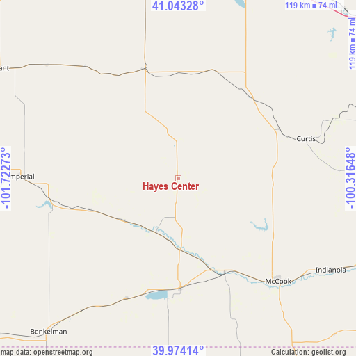
Hayes Center GPS coordinates[2]
40° 30' 39.024" North, 101° 1' 10.56" West
| Map corner | latitude | longitude |
|---|---|---|
| Upper-left | 41.04328°, | -101.72273° |
| Center: | 40.51084°, | -101.0196° |
| Lower-right: | 39.97414°, | -100.31648° |
| Map W x H: | 118.9×118.9 km | = 73.9×73.9mi |
| max Lat: | 71.29058° ⇑41% North |
| Hayes Center: | 40.51084° |
| min Lat: | ⇓59% South 19.06759° |
| min Long | Hayes Center | max Long |
| -171.73463° | -101.0196° | -66.98998° |
| W 18.7%⇐ | ⇒81.3% E |
Elevation
Elevation of Hayes Center is 936 m = 3071 ft, and this is 641.2 m = 2104 ft above average elevation for this country.
| Max E: |
3189 m = 10463 ft | 7% |
| Hayes Center | 936 m 3071 ft | |
| Avg. | 294.8 m = 967 ft | |
Min E: |
-60 m = -197 ft | 93% |
See also: United States elevation on elevation.city.
Geographical zone
Hayes Center is located in North temperate zone (between Tropic of Cancer and the Arctic Circle). Distance of this Northern Tropic circle is 1898.5 km =1179.7 mi to South.| Distance of | km | miles | from Hayes Center |
|---|---|---|---|
| North Pole | 5502.7 | 3419.2 | to North |
| Arctic Circle | 2896.8 | 1800 | to North |
| Tropic Cancer | 1898.5 | 1179.7 | to South |
| Equator | 4504.4 | 2798.9 | to South |


Nearby cities:
15 places around Hayes Center: (largest is in red/bold)
• Atwood
78.3 km =48.7 mi,  181°
181°
• Benkelman
67.3 km =41.8 mi,  220°
220°
• Cambridge
76.7 km =47.7 mi,  109°
109°
• Culbertson
34.8 km =21.6 mi,  153°
153°
• Curtis
44.6 km =27.7 mi,  72°
72°
• Grant
70 km =43.5 mi,  301°
301°
• Hershey
72 km =44.7 mi,  1°
1°
• Imperial
52.7 km =32.7 mi,  270°
270°
• Indianola
59.6 km =37 mi,  121°
121°
• McCook
47.9 km =29.8 mi,  135°
135°
• North Platte
71.4 km =44.4 mi,  17°
17°
• Stockville
53.8 km =33.4 mi,  87°
87°
• Sutherland
72.4 km =45 mi,  352°
352°
• Trenton
37.3 km =23.2 mi, 179°
• Wauneta
31.5 km =19.6 mi,  250°
250°
Sources, notices
• [Note1] Compared only with cities in United States existing in our database
• [Src1] Map data: © OpenStreetMap contributors (CC-BY-SA)
• [Src2] Other city data from geonames.org with taken over terms of usage.
• [Src3] Geographical zone / Annual Mean Temperature by Robert A. Rohde @ Wikipedia
