Imperial geodata
Imperial (Nebraska) is a seat of a second-order administrative division; located in United States in America/Denver (GMT-6) time zone. With population of 2,056 people, there are 11767 cities with bigger population in this country. Compared to other cities in United States, 59.1% of cities are located further ↓South; 81.6% of cities are located further →East and 93.4% of cities have lower elevation than Imperial. Note1


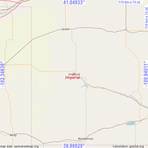
Imperial GPS coordinates[2]
40° 31' 0.984" North, 101° 38' 35.628" West
| Map corner | latitude | longitude |
|---|---|---|
| Upper-left | 41.04933°, | -102.34636° |
| Center: | 40.51694°, | -101.64323° |
| Lower-right: | 39.98029°, | -100.94011° |
| Map W x H: | 118.9×118.9 km | = 73.9×73.9mi |
| max Lat: | 71.29058° ⇑40.9% North |
| Imperial: | 40.51694° |
| min Lat: | ⇓59.1% South 19.06759° |
| min Long | Imperial | max Long |
| -171.73463° | -101.64323° | -66.98998° |
| W 18.4%⇐ | ⇒81.6% E |
Elevation
Elevation of Imperial is 1003 m = 3291 ft, and this is 708.2 m = 2323 ft above average elevation for this country.
| Max E: |
3189 m = 10463 ft | 6.6% |
| Imperial | 1003 m 3291 ft | |
| Avg. | 294.8 m = 967 ft | |
Min E: |
-60 m = -197 ft | 93.4% |
See also: United States elevation on elevation.city.
Geographical zone
Imperial is located in North temperate zone (between Tropic of Cancer and the Arctic Circle). Distance of this Northern Tropic circle is 1899.1 km =1180 mi to South.| Distance of | km | miles | from Imperial |
|---|---|---|---|
| North Pole | 5502 | 3418.8 | to North |
| Arctic Circle | 2896.1 | 1799.6 | to North |
| Tropic Cancer | 1899.1 | 1180 | to South |
| Equator | 4505.1 | 2799.3 | to South |


Nearby cities:
15 places around Imperial: (largest is in red/bold)
• Benkelman
52.8 km =32.8 mi,  169°
169°
• Culbertson
75.3 km =46.8 mi,  115°
115°
• Grant
36.8 km =22.9 mi,  349°
349°
• Haxtun
84.2 km =52.3 mi,  279°
279°
• Hayes Center
52.7 km =32.7 mi,  90°
90°
• Hershey
89.4 km =55.6 mi,  37°
37°
• Holyoke
56.2 km =34.9 mi, 277°
• Julesburg
74.1 km =46 mi,  315°
315°
• McCook
93.1 km =57.8 mi,  112°
112°
• Ogallala
68.3 km =42.4 mi, 354°
• Saint Francis
83.9 km =52.1 mi,  189°
189°
• Sutherland
83.4 km =51.8 mi,  31°
31°
• Trenton
65.5 km =40.7 mi,  125°
125°
• Wauneta
25.5 km =15.8 mi, 115°
• Wray
69.5 km =43.2 mi,  225°
225°
Sources, notices
• [Note1] Compared only with cities in United States existing in our database
• [Src1] Map data: © OpenStreetMap contributors (CC-BY-SA)
• [Src2] Other city data from geonames.org with taken over terms of usage.
• [Src3] Geographical zone / Annual Mean Temperature by Robert A. Rohde @ Wikipedia
