Ogallala geodata
Ogallala (Nebraska) is a seat of a second-order administrative division; located in United States in America/Denver (GMT-6) time zone. With population of 4,570 people, there are 7575 cities with bigger population in this country. Compared to other cities in United States, 67.2% of cities are located further ↓South; 81.7% of cities are located further →East and 93.3% of cities have lower elevation than Ogallala. Note1


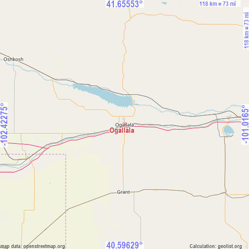
Ogallala GPS coordinates[2]
41° 7' 40.98" North, 101° 43' 10.632" West
| Map corner | latitude | longitude |
|---|---|---|
| Upper-left | 41.65553°, | -102.42275° |
| Center: | 41.12805°, | -101.71962° |
| Lower-right: | 40.59629°, | -101.0165° |
| Map W x H: | 117.8×117.8 km | = 73.2×73.2mi |
| max Lat: | 71.29058° ⇑32.8% North |
| Ogallala: | 41.12805° |
| min Lat: | ⇓67.2% South 19.06759° |
| min Long | Ogallala | max Long |
| -171.73463° | -101.71962° | -66.98998° |
| W 18.3%⇐ | ⇒81.7% E |
Elevation
Elevation of Ogallala is 985 m = 3232 ft, and this is 690.2 m = 2264 ft above average elevation for this country.
| Max E: |
3189 m = 10463 ft | 6.7% |
| Ogallala | 985 m 3232 ft | |
| Avg. | 294.8 m = 967 ft | |
Min E: |
-60 m = -197 ft | 93.3% |
See also: United States elevation on elevation.city.
Geographical zone
Ogallala is located in North temperate zone (between Tropic of Cancer and the Arctic Circle). Distance of this Northern Tropic circle is 1967.1 km =1222.3 mi to South.| Distance of | km | miles | from Ogallala |
|---|---|---|---|
| North Pole | 5434.1 | 3376.6 | to North |
| Arctic Circle | 2828.2 | 1757.4 | to North |
| Tropic Cancer | 1967.1 | 1222.3 | to South |
| Equator | 4573 | 2841.5 | to South |


Nearby cities:
15 places around Ogallala: (largest is in red/bold)
• Arthur
49.4 km =30.7 mi,  2°
2°
• Chappell
63 km =39.1 mi,  266°
266°
• Grant
31.8 km =19.8 mi,  180°
180°
• Haxtun
93.5 km =58.1 mi,  234°
234°
• Hayes Center
90.4 km =56.2 mi,  139°
139°
• Hershey
60.1 km =37.3 mi,  86°
86°
• Holyoke
77.8 km =48.3 mi,  219°
219°
• Hyannis
97.1 km =60.3 mi,  357°
357°
• Imperial
68.3 km =42.4 mi,  174°
174°
• Julesburg
48.2 km =30 mi,  251°
251°
• North Platte
79.9 km =49.6 mi, 90°
• Oshkosh
60.6 km =37.7 mi,  300°
300°
• Sutherland
49.8 km =30.9 mi, 86°
• Tryon
79.2 km =49.2 mi,  53°
53°
• Wauneta
84.2 km =52.3 mi,  159°
159°
Sources, notices
• [Note1] Compared only with cities in United States existing in our database
• [Src1] Map data: © OpenStreetMap contributors (CC-BY-SA)
• [Src2] Other city data from geonames.org with taken over terms of usage.
• [Src3] Geographical zone / Annual Mean Temperature by Robert A. Rohde @ Wikipedia
