Chiloquin geodata
Chiloquin (Oregon) is a populated place; located in United States in America/Los_Angeles (GMT-7) time zone. With population of 721 people, there are 18489 cities with bigger population in this country. Compared to other cities in United States, 80.4% of cities are located further ↓South; 94.8% of cities are located further →East and 95% of cities have lower elevation than Chiloquin. Note1


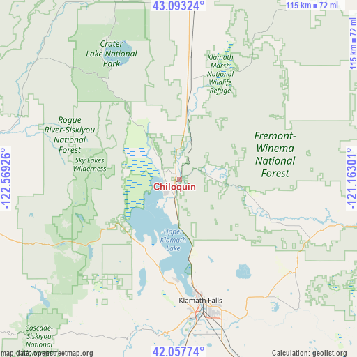
Chiloquin GPS coordinates[2]
42° 34' 39.504" North, 121° 51' 58.068" West
| Map corner | latitude | longitude |
|---|---|---|
| Upper-left | 43.09324°, | -122.56926° |
| Center: | 42.57764°, | -121.86613° |
| Lower-right: | 42.05774°, | -121.16301° |
| Map W x H: | 115.1×115.1 km | = 71.5×71.5mi |
| max Lat: | 71.29058° ⇑19.6% North |
| Chiloquin: | 42.57764° |
| min Lat: | ⇓80.4% South 19.06759° |
| min Long | Chiloquin | max Long |
| -171.73463° | -121.86613° | -66.98998° |
| W 5.2%⇐ | ⇒94.8% E |
Elevation
Elevation of Chiloquin is 1273 m = 4177 ft, and this is 978.2 m = 3209 ft above average elevation for this country.
| Max E: |
3189 m = 10463 ft | 5% |
| Chiloquin | 1273 m 4177 ft | |
| Avg. | 294.8 m = 967 ft | |
Min E: |
-60 m = -197 ft | 95% |
See also: United States elevation on elevation.city.
Geographical zone
Chiloquin is located in North temperate zone (between Tropic of Cancer and the Arctic Circle). Distance of this Northern Tropic circle is 2128.3 km =1322.5 mi to South.| Distance of | km | miles | from Chiloquin |
|---|---|---|---|
| North Pole | 5272.9 | 3276.4 | to North |
| Arctic Circle | 2667 | 1657.2 | to North |
| Tropic Cancer | 2128.3 | 1322.5 | to South |
| Equator | 4734.2 | 2941.7 | to South |


Nearby cities:
15 places around Chiloquin: (largest is in red/bold)
• Altamont
42.6 km =26.5 mi,  165°
165°
• Ashland
81.3 km =50.5 mi,  238°
238°
• Central Point
89 km =55.3 mi,  255°
255°
• Dorris
68 km =42.3 mi,  183°
183°
• Eagle Point
77.6 km =48.2 mi, 261°
• Klamath Falls
39.8 km =24.7 mi, 169°
• Malin
73.2 km =45.5 mi,  149°
149°
• Medford
87.4 km =54.3 mi,  251°
251°
• Merrill
65.2 km =40.5 mi,  160°
160°
• Phoenix
85.1 km =52.9 mi, 246°
• Shady Cove
77.6 km =48.2 mi,  272°
272°
• Talent
84.2 km =52.3 mi, 244°
• Trail
77.7 km =48.3 mi,  275°
275°
• Tulelake
76.2 km =47.3 mi, 155°
• White City
82.9 km =51.5 mi, 259°
Sources, notices
• [Note1] Compared only with cities in United States existing in our database
• [Src1] Map data: © OpenStreetMap contributors (CC-BY-SA)
• [Src2] Other city data from geonames.org with taken over terms of usage.
• [Src3] Geographical zone / Annual Mean Temperature by Robert A. Rohde @ Wikipedia
