Klamath Falls geodata
Klamath Falls (Oregon) is a seat of a second-order administrative division; located in United States in America/Los_Angeles (GMT-7) time zone. With population of 21,399 people, there are 2357 cities with bigger population in this country. Compared to other cities in United States, 77.5% of cities are located further ↓South; 94.7% of cities are located further →East and 94.9% of cities have lower elevation than Klamath Falls. Note1


Klamath Falls GPS coordinates[2]
42° 13' 29.532" North, 121° 46' 54.012" West
| Map corner | latitude | longitude |
|---|---|---|
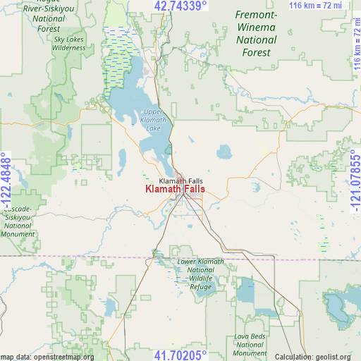
| Upper-left | 42.74339°, | -122.4848° |
| Center: | 42.22487°, | -121.78167° |
| Lower-right: | 41.70205°, | -121.07855° |
| Map W x H: | 115.8×115.8 km | = 72×72mi |
| max Lat: | 71.29058° ⇑22.5% North |
| Klamath Falls: | 42.22487° |
| min Lat: | ⇓77.5% South 19.06759° |
| min Long | Klamath Falls | max Long |
| -171.73463° | -121.78167° | -66.98998° |
| W 5.3%⇐ | ⇒94.7% E |
Elevation
Elevation of Klamath Falls is 1254 m = 4114 ft, and this is 959.2 m = 3147 ft above average elevation for this country.
| Max E: |
3189 m = 10463 ft | 5.1% |
| Klamath Falls | 1254 m 4114 ft | |
| Avg. | 294.8 m = 967 ft | |
Min E: |
-60 m = -197 ft | 94.9% |
See also: United States elevation on elevation.city.
Geographical zone
Klamath Falls is located in North temperate zone (between Tropic of Cancer and the Arctic Circle). Distance of this Northern Tropic circle is 2089 km =1298 mi to South.| Distance of | km | miles | from Klamath Falls |
|---|---|---|---|
| North Pole | 5312.1 | 3300.8 | to North |
| Arctic Circle | 2706.2 | 1681.6 | to North |
| Tropic Cancer | 2089 | 1298 | to South |
| Equator | 4695 | 2917.3 | to South |


Nearby cities:
15 places around Klamath Falls: (largest is in red/bold)
• Altamont
4.2 km =2.6 mi,  118°
118°
• Ashland
76.5 km =47.5 mi,  267°
267°
• Central Point
94.8 km =58.9 mi,  280°
280°
• Chiloquin
39.8 km =24.7 mi,  349°
349°
• Dorris
30.8 km =19.1 mi,  201°
201°
• Eagle Point
88.3 km =54.9 mi,  288°
288°
• Malin
38.8 km =24.1 mi,  127°
127°
• Medford
90.7 km =56.4 mi, 277°
• Merrill
26.8 km =16.7 mi,  146°
146°
• Montague
82.8 km =51.4 mi,  228°
228°
• Phoenix
85.5 km =53.1 mi, 273°
• Talent
82.9 km =51.5 mi, 271°
• Tulelake
39 km =24.2 mi,  139°
139°
• White City
91.6 km =56.9 mi, 284°
• Yreka
89.1 km =55.4 mi, 232°
Sources, notices
• [Note1] Compared only with cities in United States existing in our database
• [Src1] Map data: © OpenStreetMap contributors (CC-BY-SA)
• [Src2] Other city data from geonames.org with taken over terms of usage.
• [Src3] Geographical zone / Annual Mean Temperature by Robert A. Rohde @ Wikipedia
