Merrill geodata
Merrill (Oregon) is a populated place; located in United States in America/Los_Angeles (GMT-7) time zone. With population of 825 people, there are 17571 cities with bigger population in this country. Compared to other cities in United States, 75.9% of cities are located further ↓South; 94.4% of cities are located further →East and 94.9% of cities have lower elevation than Merrill. Note1


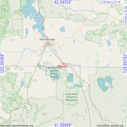
Merrill GPS coordinates[2]
42° 1' 30.54" North, 121° 36' 1.98" West
| Map corner | latitude | longitude |
|---|---|---|
| Upper-left | 42.54532°, | -122.30368° |
| Center: | 42.02515°, | -121.60055° |
| Lower-right: | 41.50069°, | -120.89743° |
| Map W x H: | 116.2×116.2 km | = 72.2×72.2mi |
| max Lat: | 71.29058° ⇑24.1% North |
| Merrill: | 42.02515° |
| min Lat: | ⇓75.9% South 19.06759° |
| min Long | Merrill | max Long |
| -171.73463° | -121.60055° | -66.98998° |
| W 5.6%⇐ | ⇒94.4% E |
Elevation
Elevation of Merrill is 1241 m = 4072 ft, and this is 946.2 m = 3104 ft above average elevation for this country.
| Max E: |
3189 m = 10463 ft | 5.1% |
| Merrill | 1241 m 4072 ft | |
| Avg. | 294.8 m = 967 ft | |
Min E: |
-60 m = -197 ft | 94.9% |
See also: United States elevation on elevation.city.
Geographical zone
Merrill is located in North temperate zone (between Tropic of Cancer and the Arctic Circle). Distance of this Northern Tropic circle is 2066.8 km =1284.2 mi to South.| Distance of | km | miles | from Merrill |
|---|---|---|---|
| North Pole | 5334.3 | 3314.6 | to North |
| Arctic Circle | 2728.4 | 1695.3 | to North |
| Tropic Cancer | 2066.8 | 1284.2 | to South |
| Equator | 4672.8 | 2903.5 | to South |


Nearby cities:
15 places around Merrill: (largest is in red/bold)
• Altamont
23.1 km =14.4 mi,  330°
330°
• Ashland
93.4 km =58 mi,  281°
281°
• California Pines
102.6 km =63.8 mi,  131°
131°
• Chiloquin
65.2 km =40.5 mi,  340°
340°
• Dorris
27 km =16.8 mi,  256°
256°
• Klamath Falls
26.8 km =16.7 mi, 326°
• Malin
15.9 km =9.9 mi,  95°
95°
• McCloud
96.6 km =60 mi,  207°
207°
• Montague
83.6 km =51.9 mi,  246°
246°
• Mount Shasta
99.1 km =61.6 mi,  216°
216°
• Phoenix
104.2 km =64.7 mi,  285°
285°
• Talent
101 km =62.8 mi, 284°
• Tulelake
12.7 km =7.9 mi, 127°
• Weed
93.5 km =58.1 mi, 224°
• Yreka
91.5 km =56.9 mi, 249°
Sources, notices
• [Note1] Compared only with cities in United States existing in our database
• [Src1] Map data: © OpenStreetMap contributors (CC-BY-SA)
• [Src2] Other city data from geonames.org with taken over terms of usage.
• [Src3] Geographical zone / Annual Mean Temperature by Robert A. Rohde @ Wikipedia
