Culver geodata
Culver (Oregon) is a populated place; located in United States in America/Los_Angeles (GMT-7) time zone. With population of 1,442 people, there are 13907 cities with bigger population in this country. Compared to other cities in United States, 90.6% of cities are located further ↓South; 94% of cities are located further →East and 92% of cities have lower elevation than Culver. Note1


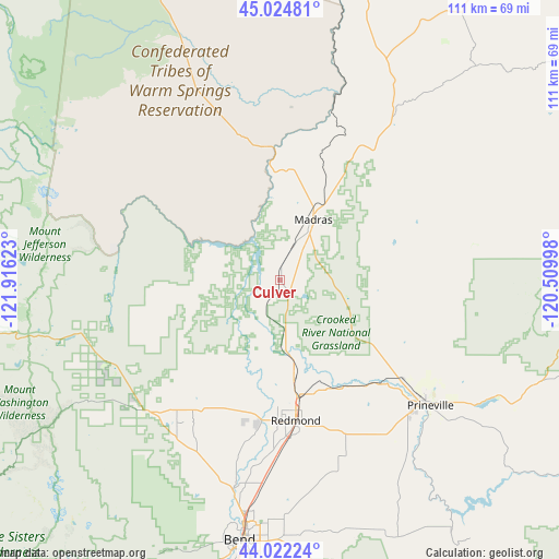
Culver GPS coordinates[2]
44° 31' 32.448" North, 121° 12' 47.16" West
| Map corner | latitude | longitude |
|---|---|---|
| Upper-left | 45.02481°, | -121.91623° |
| Center: | 44.52568°, | -121.2131° |
| Lower-right: | 44.02224°, | -120.50998° |
| Map W x H: | 111.5×111.5 km | = 69.3×69.3mi |
| max Lat: | 71.29058° ⇑9.4% North |
| Culver: | 44.52568° |
| min Lat: | ⇓90.6% South 19.06759° |
| min Long | Culver | max Long |
| -171.73463° | -121.2131° | -66.98998° |
| W 6%⇐ | ⇒94% E |
Elevation
Elevation of Culver is 802 m = 2631 ft, and this is 507.2 m = 1664 ft above average elevation for this country.
| Max E: |
3189 m = 10463 ft | 8% |
| Culver | 802 m 2631 ft | |
| Avg. | 294.8 m = 967 ft | |
Min E: |
-60 m = -197 ft | 92% |
See also: United States elevation on elevation.city.
Geographical zone
Culver is located in North temperate zone (between Tropic of Cancer and the Arctic Circle). Distance of this Northern Tropic circle is 2344.9 km =1457.1 mi to South.| Distance of | km | miles | from Culver |
|---|---|---|---|
| North Pole | 5056.3 | 3141.8 | to North |
| Arctic Circle | 2450.4 | 1522.6 | to North |
| Tropic Cancer | 2344.9 | 1457.1 | to South |
| Equator | 4950.8 | 3076.3 | to South |


Nearby cities:
15 places around Culver: (largest is in red/bold)
• Bend
52.6 km =32.7 mi,  188°
188°
• Deschutes River Woods
60.5 km =37.6 mi, 191°
• Dufur
103.3 km =64.2 mi,  3°
3°
• Fossil
94.6 km =58.8 mi,  56°
56°
• La Pine
97.9 km =60.8 mi, 193°
• Madras
13.7 km =8.5 mi,  28°
28°
• Metolius
7.3 km =4.5 mi,  22°
22°
• Mill City
103.3 km =64.2 mi,  284°
284°
• Prineville
39.2 km =24.4 mi,  129°
129°
• Redmond
28.3 km =17.6 mi,  173°
173°
• Sisters
37.3 km =23.2 mi,  225°
225°
• Sunriver
73.6 km =45.7 mi, 194°
• Terrebonne
19.4 km =12.1 mi, 171°
• Three Rivers
81.1 km =50.4 mi, 194°
• Warm Springs
26.8 km =16.7 mi,  350°
350°
Sources, notices
• [Note1] Compared only with cities in United States existing in our database
• [Src1] Map data: © OpenStreetMap contributors (CC-BY-SA)
• [Src2] Other city data from geonames.org with taken over terms of usage.
• [Src3] Geographical zone / Annual Mean Temperature by Robert A. Rohde @ Wikipedia
