Deschutes River Woods geodata
Deschutes River Woods (Oregon) is a populated place; located in United States in America/Los_Angeles (GMT-7) time zone. With population of 5,077 people, there are 7100 cities with bigger population in this country. Compared to other cities in United States, 88.4% of cities are located further ↓South; 94.2% of cities are located further →East and 94.6% of cities have lower elevation than Deschutes River Woods. Note1


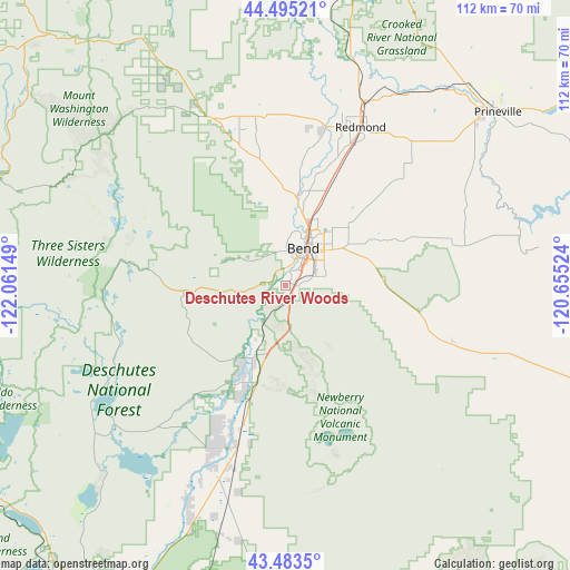
Deschutes River Woods GPS coordinates[2]
43° 59' 29.436" North, 121° 21' 30.096" West
| Map corner | latitude | longitude |
|---|---|---|
| Upper-left | 44.49521°, | -122.06149° |
| Center: | 43.99151°, | -121.35836° |
| Lower-right: | 43.4835°, | -120.65524° |
| Map W x H: | 112.5×112.5 km | = 69.9×69.9mi |
| max Lat: | 71.29058° ⇑11.6% North |
| Deschutes River Woods: | 43.99151° |
| min Lat: | ⇓88.4% South 19.06759° |
| min Long | Deschutes River | max Long |
| -171.73463° | -121.35836° | -66.98998° |
| W 5.8%⇐ | ⇒94.2% E |
Elevation
Elevation of Deschutes River Woods is 1198 m = 3930 ft, and this is 903.2 m = 2963 ft above average elevation for this country.
| Max E: |
3189 m = 10463 ft | 5.4% |
| Deschutes River Woods | 1198 m 3930 ft | |
| Avg. | 294.8 m = 967 ft | |
Min E: |
-60 m = -197 ft | 94.6% |
See also: United States elevation on elevation.city.
Geographical zone
Deschutes River Woods is located in North temperate zone (between Tropic of Cancer and the Arctic Circle). Distance of this Northern Tropic circle is 2285.5 km =1420.1 mi to South.| Distance of | km | miles | from Deschutes River Woods |
|---|---|---|---|
| North Pole | 5115.7 | 3178.7 | to North |
| Arctic Circle | 2509.8 | 1559.5 | to North |
| Tropic Cancer | 2285.5 | 1420.1 | to South |
| Equator | 4891.4 | 3039.4 | to South |


Nearby cities:
15 places around Deschutes River Woods: (largest is in red/bold)
• Bend
8.2 km =5.1 mi,  24°
24°
• Culver
60.5 km =37.6 mi,  11°
11°
• La Pine
37.6 km =23.4 mi,  198°
198°
• Lowell
114.4 km =71.1 mi,  265°
265°
• Madras
73.7 km =45.8 mi, 14°
• Metolius
67.7 km =42.1 mi, 12°
• Oakridge
92.5 km =57.5 mi,  252°
252°
• Prineville
54.1 km =33.6 mi,  50°
50°
• Redmond
34.5 km =21.4 mi,  25°
25°
• Sisters
36.6 km =22.7 mi,  335°
335°
• Sunriver
13.6 km =8.5 mi,  208°
208°
• Sweet Home
118.8 km =73.8 mi,  292°
292°
• Terrebonne
42.7 km =26.5 mi, 19°
• Three Rivers
21 km =13 mi, 204°
• Warm Springs
86.1 km =53.5 mi,  4°
4°
Sources, notices
• [Note1] Compared only with cities in United States existing in our database
• [Src1] Map data: © OpenStreetMap contributors (CC-BY-SA)
• [Src2] Other city data from geonames.org with taken over terms of usage.
• [Src3] Geographical zone / Annual Mean Temperature by Robert A. Rohde @ Wikipedia
