La Pine geodata
La Pine (Oregon) is a populated place; located in United States in America/Los_Angeles (GMT-7) time zone. With population of 1,777 people, there are 12636 cities with bigger population in this country. Compared to other cities in United States, 87.1% of cities are located further ↓South; 94.3% of cities are located further →East and 95.1% of cities have lower elevation than La Pine. Note1


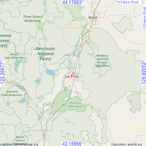
La Pine GPS coordinates[2]
43° 40' 13.44" North, 121° 30' 13.104" West
| Map corner | latitude | longitude |
|---|---|---|
| Upper-left | 44.17683°, | -122.20677° |
| Center: | 43.6704°, | -121.50364° |
| Lower-right: | 43.15966°, | -120.80052° |
| Map W x H: | 113.1×113.1 km | = 70.3×70.3mi |
| max Lat: | 71.29058° ⇑12.9% North |
| La Pine: | 43.6704° |
| min Lat: | ⇓87.1% South 19.06759° |
| min Long | La Pine | max Long |
| -171.73463° | -121.50364° | -66.98998° |
| W 5.7%⇐ | ⇒94.3% E |
Elevation
Elevation of La Pine is 1289 m = 4229 ft, and this is 994.2 m = 3262 ft above average elevation for this country.
| Max E: |
3189 m = 10463 ft | 4.9% |
| La Pine | 1289 m 4229 ft | |
| Avg. | 294.8 m = 967 ft | |
Min E: |
-60 m = -197 ft | 95.1% |
See also: United States elevation on elevation.city.
Geographical zone
La Pine is located in North temperate zone (between Tropic of Cancer and the Arctic Circle). Distance of this Northern Tropic circle is 2249.8 km =1398 mi to South.| Distance of | km | miles | from La Pine |
|---|---|---|---|
| North Pole | 5151.4 | 3200.9 | to North |
| Arctic Circle | 2545.5 | 1581.7 | to North |
| Tropic Cancer | 2249.8 | 1398 | to South |
| Equator | 4855.7 | 3017.2 | to South |


Nearby cities:
15 places around La Pine: (largest is in red/bold)
• Bend
45.7 km =28.4 mi,  19°
19°
• Culp Creek
108.1 km =67.2 mi,  271°
271°
• Culver
97.9 km =60.8 mi,  13°
13°
• Deschutes River Woods
37.6 km =23.4 mi, 18°
• Lowell
106.4 km =66.1 mi,  285°
285°
• Madras
111.2 km =69.1 mi, 15°
• Metolius
105.1 km =65.3 mi, 14°
• Oakridge
77.5 km =48.2 mi,  276°
276°
• Prineville
88.1 km =54.7 mi,  37°
37°
• Redmond
72 km =44.7 mi, 21°
• Sisters
69.1 km =42.9 mi,  356°
356°
• Sunriver
24.3 km =15.1 mi, 12°
• Terrebonne
80.2 km =49.8 mi, 18°
• Three Rivers
16.9 km =10.5 mi, 9°
• Warm Springs
123 km =76.4 mi, 8°
Sources, notices
• [Note1] Compared only with cities in United States existing in our database
• [Src1] Map data: © OpenStreetMap contributors (CC-BY-SA)
• [Src2] Other city data from geonames.org with taken over terms of usage.
• [Src3] Geographical zone / Annual Mean Temperature by Robert A. Rohde @ Wikipedia
