Redmond geodata
Redmond (Oregon) is a populated place; located in United States in America/Los_Angeles (GMT-7) time zone. With population of 28,654 people, there are 1741 cities with bigger population in this country. Compared to other cities in United States, 89.5% of cities are located further ↓South; 93.9% of cities are located further →East and 92.9% of cities have lower elevation than Redmond. Note1


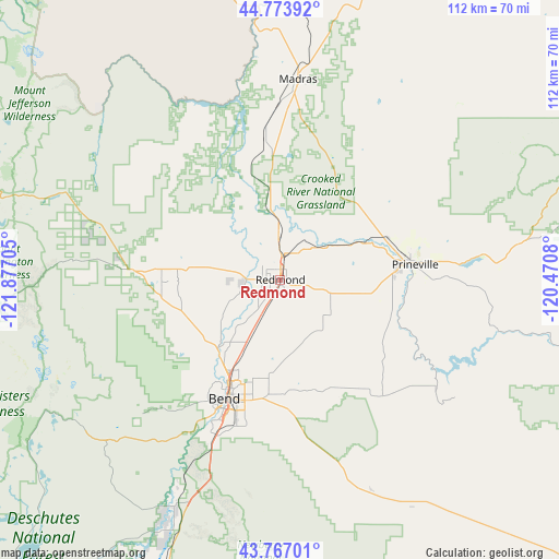
Redmond GPS coordinates[2]
44° 16' 21.432" North, 121° 10' 26.112" West
| Map corner | latitude | longitude |
|---|---|---|
| Upper-left | 44.77392°, | -121.87705° |
| Center: | 44.27262°, | -121.17392° |
| Lower-right: | 43.76701°, | -120.4708° |
| Map W x H: | 112×112 km | = 69.6×69.6mi |
| max Lat: | 71.29058° ⇑10.5% North |
| Redmond: | 44.27262° |
| min Lat: | ⇓89.5% South 19.06759° |
| min Long | Redmond | max Long |
| -171.73463° | -121.17392° | -66.98998° |
| W 6.1%⇐ | ⇒93.9% E |
Elevation
Elevation of Redmond is 912 m = 2992 ft, and this is 617.2 m = 2025 ft above average elevation for this country.
| Max E: |
3189 m = 10463 ft | 7.1% |
| Redmond | 912 m 2992 ft | |
| Avg. | 294.8 m = 967 ft | |
Min E: |
-60 m = -197 ft | 92.9% |
See also: United States elevation on elevation.city.
Geographical zone
Redmond is located in North temperate zone (between Tropic of Cancer and the Arctic Circle). Distance of this Northern Tropic circle is 2316.7 km =1439.5 mi to South.| Distance of | km | miles | from Redmond |
|---|---|---|---|
| North Pole | 5084.4 | 3159.3 | to North |
| Arctic Circle | 2478.5 | 1540.1 | to North |
| Tropic Cancer | 2316.7 | 1439.5 | to South |
| Equator | 4922.7 | 3058.8 | to South |


Nearby cities:
15 places around Redmond: (largest is in red/bold)
• Bend
26.4 km =16.4 mi,  205°
205°
• Culver
28.3 km =17.6 mi,  353°
353°
• Deschutes River Woods
34.5 km =21.4 mi, 205°
• Fossil
110.7 km =68.8 mi,  43°
43°
• La Pine
72 km =44.7 mi,  201°
201°
• Madras
40.3 km =25 mi,  5°
5°
• Metolius
34.9 km =21.7 mi,  359°
359°
• Mill City
116.4 km =72.3 mi,  297°
297°
• Oakridge
118.4 km =73.6 mi,  240°
240°
• Prineville
27.2 km =16.9 mi,  83°
83°
• Sisters
29.9 km =18.6 mi,  273°
273°
• Sunriver
48.1 km =29.9 mi, 206°
• Terrebonne
8.9 km =5.5 mi, 358°
• Three Rivers
55.6 km =34.5 mi, 205°
• Warm Springs
55.1 km =34.2 mi, 352°
Sources, notices
• [Note1] Compared only with cities in United States existing in our database
• [Src1] Map data: © OpenStreetMap contributors (CC-BY-SA)
• [Src2] Other city data from geonames.org with taken over terms of usage.
• [Src3] Geographical zone / Annual Mean Temperature by Robert A. Rohde @ Wikipedia
