Bend geodata
Bend (Oregon) is a seat of a second-order administrative division; located in United States in America/Los_Angeles (GMT-7) time zone. With population of 87,014 people, there are 439 cities with bigger population in this country. Compared to other cities in United States, 88.7% of cities are located further ↓South; 94.1% of cities are located further →East and 94% of cities have lower elevation than Bend. Note1


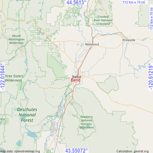
Bend GPS coordinates[2]
44° 3' 29.412" North, 121° 18' 55.116" West
| Map corner | latitude | longitude |
|---|---|---|
| Upper-left | 44.5613°, | -122.01844° |
| Center: | 44.05817°, | -121.31531° |
| Lower-right: | 43.55072°, | -120.61219° |
| Map W x H: | 112.4×112.4 km | = 69.8×69.8mi |
| max Lat: | 71.29058° ⇑11.3% North |
| Bend: | 44.05817° |
| min Lat: | ⇓88.7% South 19.06759° |
| min Long | Bend | max Long |
| -171.73463° | -121.31531° | -66.98998° |
| W 5.9%⇐ | ⇒94.1% E |
Elevation
Elevation of Bend is 1106 m = 3629 ft, and this is 811.2 m = 2661 ft above average elevation for this country.
| Max E: |
3189 m = 10463 ft | 6% |
| Bend | 1106 m 3629 ft | |
| Avg. | 294.8 m = 967 ft | |
Min E: |
-60 m = -197 ft | 94% |
See also: Bend elevation on elevation.city.
Geographical zone
Bend is located in North temperate zone (between Tropic of Cancer and the Arctic Circle). Distance of this Northern Tropic circle is 2292.9 km =1424.7 mi to South.| Distance of | km | miles | from Bend |
|---|---|---|---|
| North Pole | 5108.3 | 3174.1 | to North |
| Arctic Circle | 2502.4 | 1554.9 | to North |
| Tropic Cancer | 2292.9 | 1424.7 | to South |
| Equator | 4898.8 | 3044 | to South |


Nearby cities:
15 places around Bend: (largest is in red/bold)
• Culver
52.6 km =32.7 mi,  8°
8°
• Deschutes River Woods
8.2 km =5.1 mi,  204°
204°
• La Pine
45.7 km =28.4 mi, 199°
• Lowell
118.5 km =73.6 mi,  262°
262°
• Madras
65.6 km =40.8 mi, 13°
• Metolius
59.7 km =37.1 mi, 10°
• Oakridge
98.2 km =61 mi,  249°
249°
• Prineville
46.8 km =29.1 mi,  54°
54°
• Redmond
26.4 km =16.4 mi,  25°
25°
• Sisters
31.9 km =19.8 mi,  324°
324°
• Sunriver
21.7 km =13.5 mi,  207°
207°
• Sweet Home
119.3 km =74.1 mi,  288°
288°
• Terrebonne
34.6 km =21.5 mi,  18°
18°
• Three Rivers
29.2 km =18.1 mi, 204°
• Warm Springs
78.5 km =48.8 mi,  2°
2°
Sources, notices
• [Note1] Compared only with cities in United States existing in our database
• [Src1] Map data: © OpenStreetMap contributors (CC-BY-SA)
• [Src2] Other city data from geonames.org with taken over terms of usage.
• [Src3] Geographical zone / Annual Mean Temperature by Robert A. Rohde @ Wikipedia
