Lowell geodata
Lowell (Oregon) is a populated place; located in United States in America/Los_Angeles (GMT-7) time zone. With population of 1,087 people, there are 15748 cities with bigger population in this country. Compared to other cities in United States, 88.1% of cities are located further ↓South; 97.4% of cities are located further →East and 56.4% of cities have lower elevation than Lowell. Note1


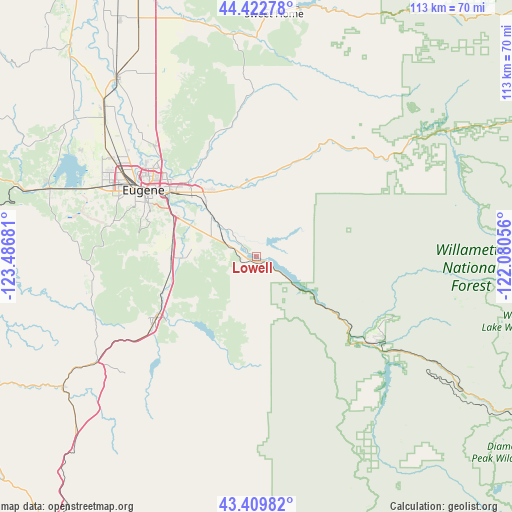
Lowell GPS coordinates[2]
43° 55' 6.456" North, 122° 47' 1.248" West
| Map corner | latitude | longitude |
|---|---|---|
| Upper-left | 44.42278°, | -123.48681° |
| Center: | 43.91846°, | -122.78368° |
| Lower-right: | 43.40982°, | -122.08056° |
| Map W x H: | 112.6×112.6 km | = 70×70mi |
| max Lat: | 71.29058° ⇑11.9% North |
| Lowell: | 43.91846° |
| min Lat: | ⇓88.1% South 19.06759° |
| min Long | Lowell | max Long |
| -171.73463° | -122.78368° | -66.98998° |
| W 2.6%⇐ | ⇒97.4% E |
Elevation
Elevation of Lowell is 224 m = 735 ft, and this is 70.8 m = 232 ft below average elevation for this country.
| Max E: |
3189 m = 10463 ft | 43.6% |
| Avg. | 294.8 m = 967 ft | |
| Lowell | 224 m = 735 ft | |
Min E: |
-60 m = -197 ft | 56.4% |
See also: United States elevation on elevation.city.
Geographical zone
Lowell is located in North temperate zone (between Tropic of Cancer and the Arctic Circle). Distance of this Northern Tropic circle is 2277.4 km =1415.1 mi to South.| Distance of | km | miles | from Lowell |
|---|---|---|---|
| North Pole | 5123.8 | 3183.8 | to North |
| Arctic Circle | 2517.9 | 1564.6 | to North |
| Tropic Cancer | 2277.4 | 1415.1 | to South |
| Equator | 4883.3 | 3034.3 | to South |


Nearby cities:
15 places around Lowell: (largest is in red/bold)
• Brownsville
55.2 km =34.3 mi,  343°
343°
• Coburg
33.2 km =20.6 mi,  317°
317°
• Cottage Grove
25.9 km =16.1 mi,  238°
238°
• Creswell
19.3 km =12 mi,  269°
269°
• Culp Creek
24.4 km =15.2 mi,  192°
192°
• Drain
51.8 km =32.2 mi, 236°
• Eugene
28.4 km =17.6 mi,  301°
301°
• Halsey
57.9 km =36 mi,  333°
333°
• Harrisburg
50.2 km =31.2 mi, 321°
• Junction City
47.5 km =29.5 mi,  314°
314°
• Oakridge
32.1 km =19.9 mi,  126°
126°
• Springfield
23.8 km =14.8 mi, 306°
• Sweet Home
53.4 km =33.2 mi,  4°
4°
• Veneta
47.6 km =29.6 mi,  287°
287°
• Yoncalla
53.6 km =33.3 mi,  228°
228°
Sources, notices
• [Note1] Compared only with cities in United States existing in our database
• [Src1] Map data: © OpenStreetMap contributors (CC-BY-SA)
• [Src2] Other city data from geonames.org with taken over terms of usage.
• [Src3] Geographical zone / Annual Mean Temperature by Robert A. Rohde @ Wikipedia
