Forest Grove geodata
Forest Grove (Oregon) is a populated place; located in United States in America/Los_Angeles (GMT-7) time zone. With population of 23,897 people, there are 2117 cities with bigger population in this country. Compared to other cities in United States, 94.1% of cities are located further ↓South; 98% of cities are located further →East and 76.2% of cities have higher elevation than Forest Grove. Note1


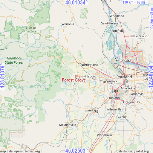
Forest Grove GPS coordinates[2]
45° 31' 11.424" North, 123° 6' 38.376" West
| Map corner | latitude | longitude |
|---|---|---|
| Upper-left | 46.01034°, | -123.81379° |
| Center: | 45.51984°, | -123.11066° |
| Lower-right: | 45.02503°, | -122.40754° |
| Map W x H: | 109.6×109.6 km | = 68.1×68.1mi |
| max Lat: | 71.29058° ⇑5.9% North |
| Forest Grove: | 45.51984° |
| min Lat: | ⇓94.1% South 19.06759° |
| min Long | Forest Grove | max Long |
| -171.73463° | -123.11066° | -66.98998° |
| W 2%⇐ | ⇒98% E |
Elevation
Elevation of Forest Grove is 65 m = 213 ft, and this is 229.8 m = 754 ft below average elevation for this country.
| Max E: |
3189 m = 10463 ft | 76.2% |
| Avg. | 294.8 m = 967 ft | |
| Forest Grove | 65 m = 213 ft | |
Min E: |
-60 m = -197 ft | 23.8% |
See also: United States elevation on elevation.city.
Geographical zone
Forest Grove is located in North temperate zone (between Tropic of Cancer and the Arctic Circle). Distance of this North polar circle is 2339.8 km =1453.9 mi to North.| Distance of | km | miles | from Forest Grove |
|---|---|---|---|
| North Pole | 4945.7 | 3073.1 | to North |
| Arctic Circle | 2339.8 | 1453.9 | to North |
| Tropic Cancer | 2455.4 | 1525.7 | to South |
| Equator | 5061.3 | 3144.9 | to South |


Nearby cities:
15 places around Forest Grove: (largest is in red/bold)
• Aloha
19.2 km =11.9 mi,  98°
98°
• Banks
11 km =6.8 mi,  358°
358°
• Beaverton
24.2 km =15 mi, 98°
• Bethany
19.4 km =12.1 mi,  77°
77°
• Carlton
25.6 km =15.9 mi,  191°
191°
• Cedar Hills
24.4 km =15.2 mi,  93°
93°
• Cedar Mill
23.4 km =14.5 mi, 88°
• Cornelius
4 km =2.5 mi, 90°
• Gaston
9.6 km =6 mi, 193°
• Hillsboro
9.4 km =5.8 mi, 87°
• North Plains
12.5 km =7.8 mi,  46°
46°
• Oak Hills
21.1 km =13.1 mi, 83°
• Rockcreek
18.5 km =11.5 mi, 79°
• West Haven
26.6 km =16.5 mi, 90°
• Yamhill
20.7 km =12.9 mi,  196°
196°
Sources, notices
• [Note1] Compared only with cities in United States existing in our database
• [Src1] Map data: © OpenStreetMap contributors (CC-BY-SA)
• [Src2] Other city data from geonames.org with taken over terms of usage.
• [Src3] Geographical zone / Annual Mean Temperature by Robert A. Rohde @ Wikipedia
