North Plains geodata
North Plains (Oregon) is a populated place; located in United States in America/Los_Angeles (GMT-7) time zone. With population of 2,100 people, there are 11617 cities with bigger population in this country. Compared to other cities in United States, 94.3% of cities are located further ↓South; 97.8% of cities are located further →East and 76.7% of cities have higher elevation than North Plains. Note1


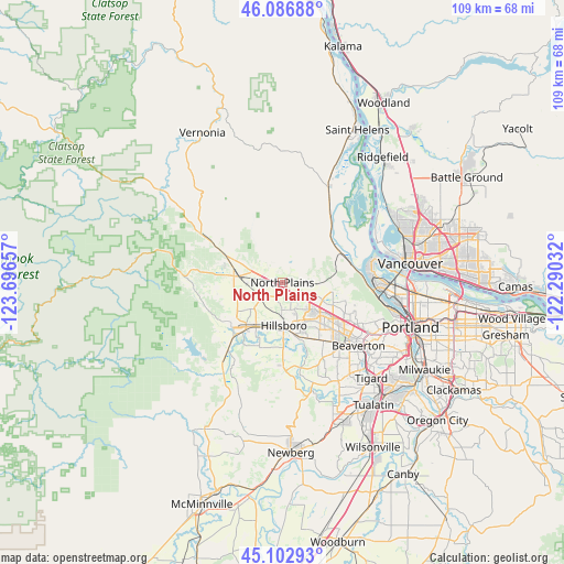
North Plains GPS coordinates[2]
45° 35' 49.416" North, 122° 59' 36.384" West
| Map corner | latitude | longitude |
|---|---|---|
| Upper-left | 46.08688°, | -123.69657° |
| Center: | 45.59706°, | -122.99344° |
| Lower-right: | 45.10293°, | -122.29032° |
| Map W x H: | 109.4×109.4 km | = 68×68mi |
| max Lat: | 71.29058° ⇑5.7% North |
| North Plains: | 45.59706° |
| min Lat: | ⇓94.3% South 19.06759° |
| min Long | North Plains | max Long |
| -171.73463° | -122.99344° | -66.98998° |
| W 2.2%⇐ | ⇒97.8% E |
Elevation
Elevation of North Plains is 62 m = 203 ft, and this is 232.8 m = 764 ft below average elevation for this country.
| Max E: |
3189 m = 10463 ft | 76.7% |
| Avg. | 294.8 m = 967 ft | |
| North Plains | 62 m = 203 ft | |
Min E: |
-60 m = -197 ft | 23.3% |
See also: United States elevation on elevation.city.
Geographical zone
North Plains is located in North temperate zone (between Tropic of Cancer and the Arctic Circle). Distance of this North polar circle is 2331.3 km =1448.6 mi to North.| Distance of | km | miles | from North Plains |
|---|---|---|---|
| North Pole | 4937.1 | 3067.8 | to North |
| Arctic Circle | 2331.3 | 1448.6 | to North |
| Tropic Cancer | 2464 | 1531.1 | to South |
| Equator | 5069.9 | 3150.3 | to South |


Nearby cities:
15 places around North Plains: (largest is in red/bold)
• Aloha
15.1 km =9.4 mi,  139°
139°
• Banks
9.7 km =6 mi,  284°
284°
• Beaverton
19.2 km =11.9 mi,  129°
129°
• Bethany
10.7 km =6.6 mi,  113°
113°
• Cedar Hills
18.3 km =11.4 mi,  124°
124°
• Cedar Mill
16.3 km =10.1 mi, 119°
• Cornelius
10 km =6.2 mi,  211°
211°
• Forest Grove
12.5 km =7.8 mi,  226°
226°
• Hillsboro
8.3 km =5.2 mi,  178°
178°
• Oak Hills
13.4 km =8.3 mi, 117°
• Rockcreek
10.5 km =6.5 mi, 119°
• Scappoose
19.7 km =12.2 mi,  27°
27°
• West Haven
19.5 km =12.1 mi, 116°
• West Haven-Sylvan
19.7 km =12.2 mi, 117°
• West Slope
20.9 km =13 mi, 121°
Sources, notices
• [Note1] Compared only with cities in United States existing in our database
• [Src1] Map data: © OpenStreetMap contributors (CC-BY-SA)
• [Src2] Other city data from geonames.org with taken over terms of usage.
• [Src3] Geographical zone / Annual Mean Temperature by Robert A. Rohde @ Wikipedia
