Sandy geodata
Sandy (Oregon) is a populated place; located in United States in America/Los_Angeles (GMT-7) time zone. With population of 10,644 people, there are 4286 cities with bigger population in this country. Compared to other cities in United States, 93.7% of cities are located further ↓South; 95.9% of cities are located further →East and 72% of cities have lower elevation than Sandy. Note1


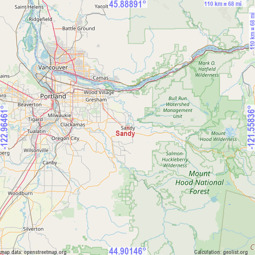
Sandy GPS coordinates[2]
45° 23' 50.424" North, 122° 15' 41.328" West
| Map corner | latitude | longitude |
|---|---|---|
| Upper-left | 45.88891°, | -122.96461° |
| Center: | 45.39734°, | -122.26148° |
| Lower-right: | 44.90146°, | -121.55836° |
| Map W x H: | 109.8×109.8 km | = 68.2×68.2mi |
| max Lat: | 71.29058° ⇑6.3% North |
| Sandy: | 45.39734° |
| min Lat: | ⇓93.7% South 19.06759° |
| min Long | Sandy | max Long |
| -171.73463° | -122.26148° | -66.98998° |
| W 4.1%⇐ | ⇒95.9% E |
Elevation
Elevation of Sandy is 296 m = 971 ft, and this is 1.2 m = 4 ft above average elevation for this country.
| Max E: |
3189 m = 10463 ft | 28% |
| Sandy | 296 m 971 ft | |
| Avg. | 294.8 m = 967 ft | |
Min E: |
-60 m = -197 ft | 72% |
See also: United States elevation on elevation.city.
Geographical zone
Sandy is located in North temperate zone (between Tropic of Cancer and the Arctic Circle). Distance of this North polar circle is 2353.5 km =1462.4 mi to North.| Distance of | km | miles | from Sandy |
|---|---|---|---|
| North Pole | 4959.4 | 3081.6 | to North |
| Arctic Circle | 2353.5 | 1462.4 | to North |
| Tropic Cancer | 2441.8 | 1517.3 | to South |
| Equator | 5047.7 | 3136.5 | to South |


Nearby cities:
15 places around Sandy: (largest is in red/bold)
• Beavercreek
24.6 km =15.3 mi,  240°
240°
• Camas
23.7 km =14.7 mi,  332°
332°
• Clackamas
24.1 km =15 mi,  272°
272°
• Damascus
15.6 km =9.7 mi,  278°
278°
• Estacada
13.2 km =8.2 mi,  205°
205°
• Fairview
20.7 km =12.9 mi,  319°
319°
• Gladstone
26.1 km =16.2 mi, 265°
• Gresham
17.4 km =10.8 mi,  310°
310°
• Happy Valley
21.7 km =13.5 mi, 284°
• Johnson City
24.8 km =15.4 mi, 271°
• Lents
25.6 km =15.9 mi,  291°
291°
• Mount Hood Village
22.4 km =13.9 mi,  102°
102°
• Troutdale
18.6 km =11.6 mi, 328°
• Washougal
21.8 km =13.5 mi,  340°
340°
• Wood Village
19.5 km =12.1 mi, 321°
Sources, notices
• [Note1] Compared only with cities in United States existing in our database
• [Src1] Map data: © OpenStreetMap contributors (CC-BY-SA)
• [Src2] Other city data from geonames.org with taken over terms of usage.
• [Src3] Geographical zone / Annual Mean Temperature by Robert A. Rohde @ Wikipedia
