Bluffdale geodata
Bluffdale (Utah) is a populated place; located in United States in America/Denver (GMT-6) time zone. With population of 10,931 people, there are 4192 cities with bigger population in this country. Compared to other cities in United States, 58.8% of cities are located further ↓South; 87.3% of cities are located further →East and 95.6% of cities have lower elevation than Bluffdale. Note1


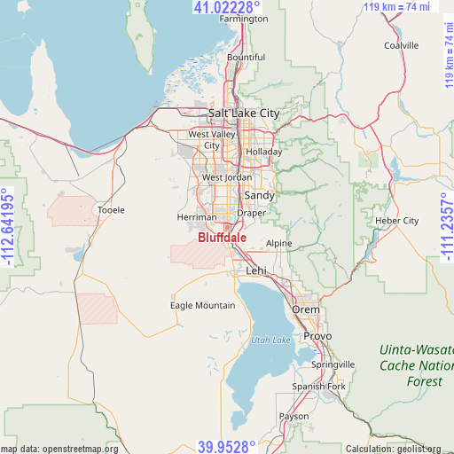
Bluffdale GPS coordinates[2]
40° 29' 22.812" North, 111° 56' 19.752" West
| Map corner | latitude | longitude |
|---|---|---|
| Upper-left | 41.02228°, | -112.64195° |
| Center: | 40.48967°, | -111.93882° |
| Lower-right: | 39.9528°, | -111.2357° |
| Map W x H: | 118.9×118.9 km | = 73.9×73.9mi |
| max Lat: | 71.29058° ⇑41.2% North |
| Bluffdale: | 40.48967° |
| min Lat: | ⇓58.8% South 19.06759° |
| min Long | Bluffdale | max Long |
| -171.73463° | -111.93882° | -66.98998° |
| W 12.7%⇐ | ⇒87.3% E |
Elevation
Elevation of Bluffdale is 1357 m = 4452 ft, and this is 1062.2 m = 3485 ft above average elevation for this country.
| Max E: |
3189 m = 10463 ft | 4.4% |
| Bluffdale | 1357 m 4452 ft | |
| Avg. | 294.8 m = 967 ft | |
Min E: |
-60 m = -197 ft | 95.6% |
See also: United States elevation on elevation.city.
Geographical zone
Bluffdale is located in North temperate zone (between Tropic of Cancer and the Arctic Circle). Distance of this Northern Tropic circle is 1896.1 km =1178.2 mi to South.| Distance of | km | miles | from Bluffdale |
|---|---|---|---|
| North Pole | 5505 | 3420.6 | to North |
| Arctic Circle | 2899.1 | 1801.4 | to North |
| Tropic Cancer | 1896.1 | 1178.2 | to South |
| Equator | 4502 | 2797.4 | to South |


Nearby cities:
15 places around Bluffdale: (largest is in red/bold)
• Alpine
14.2 km =8.8 mi,  106°
106°
• Draper
7.4 km =4.6 mi,  58°
58°
• Granite
14.6 km =9.1 mi,  50°
50°
• Herriman
8.4 km =5.2 mi,  288°
288°
• Highland
14.1 km =8.8 mi,  120°
120°
• Lehi
13.2 km =8.2 mi,  145°
145°
• Little Cottonwood Creek Valley
15.8 km =9.8 mi,  35°
35°
• Midvale
13.9 km =8.6 mi,  13°
13°
• Riverton
3.6 km =2.2 mi,  359°
359°
• Sandy
12.2 km =7.6 mi,  22°
22°
• Sandy Hills
12.6 km =7.8 mi, 36°
• South Jordan
8.1 km =5 mi, 5°
• South Jordan Heights
8.3 km =5.2 mi,  353°
353°
• West Jordan
13.3 km =8.3 mi, 359°
• White City
10.5 km =6.5 mi, 36°
Sources, notices
• [Note1] Compared only with cities in United States existing in our database
• [Src1] Map data: © OpenStreetMap contributors (CC-BY-SA)
• [Src2] Other city data from geonames.org with taken over terms of usage.
• [Src3] Geographical zone / Annual Mean Temperature by Robert A. Rohde @ Wikipedia
