Draper geodata
Draper (Utah) is a populated place; located in United States in America/Denver (GMT-6) time zone. With population of 46,774 people, there are 1028 cities with bigger population in this country. Compared to other cities in United States, 59.1% of cities are located further ↓South; 87.1% of cities are located further →East and 95.8% of cities have lower elevation than Draper. Note1


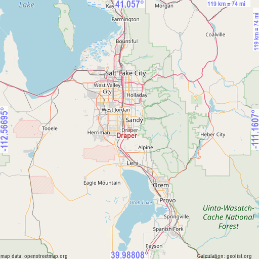
Draper GPS coordinates[2]
40° 31' 28.812" North, 111° 51' 49.752" West
| Map corner | latitude | longitude |
|---|---|---|
| Upper-left | 41.057°, | -112.56695° |
| Center: | 40.52467°, | -111.86382° |
| Lower-right: | 39.98808°, | -111.1607° |
| Map W x H: | 118.9×118.9 km | = 73.9×73.9mi |
| max Lat: | 71.29058° ⇑40.9% North |
| Draper: | 40.52467° |
| min Lat: | ⇓59.1% South 19.06759° |
| min Long | Draper | max Long |
| -171.73463° | -111.86382° | -66.98998° |
| W 12.9%⇐ | ⇒87.1% E |
Elevation
Elevation of Draper is 1377 m = 4518 ft, and this is 1082.2 m = 3551 ft above average elevation for this country.
| Max E: |
3189 m = 10463 ft | 4.2% |
| Draper | 1377 m 4518 ft | |
| Avg. | 294.8 m = 967 ft | |
Min E: |
-60 m = -197 ft | 95.8% |
See also: Draper elevation on elevation.city.
Geographical zone
Draper is located in North temperate zone (between Tropic of Cancer and the Arctic Circle). Distance of this Northern Tropic circle is 1900 km =1180.6 mi to South.| Distance of | km | miles | from Draper |
|---|---|---|---|
| North Pole | 5501.1 | 3418.2 | to North |
| Arctic Circle | 2895.3 | 1799.1 | to North |
| Tropic Cancer | 1900 | 1180.6 | to South |
| Equator | 4505.9 | 2799.8 | to South |


Nearby cities:
15 places around Draper: (largest is in red/bold)
• Alpine
10.8 km =6.7 mi,  137°
137°
• Bluffdale
7.4 km =4.6 mi,  238°
238°
• Cottonwood Heights
11.5 km =7.1 mi,  23°
23°
• Granite
7.3 km =4.5 mi,  42°
42°
• Herriman
14.3 km =8.9 mi,  265°
265°
• Highland
12.5 km =7.8 mi,  151°
151°
• Little Cottonwood Creek Valley
9.3 km =5.8 mi, 18°
• Midvale
10.1 km =6.3 mi,  342°
342°
• Riverton
6.4 km =4 mi, 267°
• Sandy
7.6 km =4.7 mi,  347°
347°
• Sandy Hills
6.4 km =4 mi,  9°
9°
• South Jordan
7 km =4.3 mi,  306°
306°
• South Jordan Heights
8.4 km =5.2 mi,  301°
301°
• West Jordan
11.4 km =7.1 mi,  326°
326°
• White City
4.6 km =2.9 mi,  359°
359°
Sources, notices
• [Note1] Compared only with cities in United States existing in our database
• [Src1] Map data: © OpenStreetMap contributors (CC-BY-SA)
• [Src2] Other city data from geonames.org with taken over terms of usage.
• [Src3] Geographical zone / Annual Mean Temperature by Robert A. Rohde @ Wikipedia
