Garland geodata
Garland (Utah) is a populated place; located in United States in America/Denver (GMT-6) time zone. With population of 2,448 people, there are 10747 cities with bigger population in this country. Compared to other cities in United States, 73.3% of cities are located further ↓South; 87.8% of cities are located further →East and 95.4% of cities have lower elevation than Garland. Note1


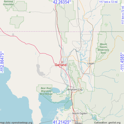
Garland GPS coordinates[2]
41° 44' 27.744" North, 112° 9' 41.832" West
| Map corner | latitude | longitude |
|---|---|---|
| Upper-left | 42.26354°, | -112.86475° |
| Center: | 41.74104°, | -112.16162° |
| Lower-right: | 41.21425°, | -111.4585° |
| Map W x H: | 116.7×116.7 km | = 72.5×72.5mi |
| max Lat: | 71.29058° ⇑26.7% North |
| Garland: | 41.74104° |
| min Lat: | ⇓73.3% South 19.06759° |
| min Long | Garland | max Long |
| -171.73463° | -112.16162° | -66.98998° |
| W 12.2%⇐ | ⇒87.8% E |
Elevation
Elevation of Garland is 1322 m = 4337 ft, and this is 1027.2 m = 3370 ft above average elevation for this country.
| Max E: |
3189 m = 10463 ft | 4.6% |
| Garland | 1322 m 4337 ft | |
| Avg. | 294.8 m = 967 ft | |
Min E: |
-60 m = -197 ft | 95.4% |
See also: United States elevation on elevation.city.
Geographical zone
Garland is located in North temperate zone (between Tropic of Cancer and the Arctic Circle). Distance of this Northern Tropic circle is 2035.2 km =1264.6 mi to South.| Distance of | km | miles | from Garland |
|---|---|---|---|
| North Pole | 5365.9 | 3334.2 | to North |
| Arctic Circle | 2760 | 1715 | to North |
| Tropic Cancer | 2035.2 | 1264.6 | to South |
| Equator | 4641.2 | 2883.9 | to South |


Nearby cities:
15 places around Garland: (largest is in red/bold)
• Amalga
25.8 km =16 mi,  58°
58°
• Bear River City
14.4 km =8.9 mi,  168°
168°
• Benson
19.9 km =12.4 mi,  74°
74°
• Clarkston
22 km =13.7 mi,  24°
24°
• Corinne
21.6 km =13.4 mi, 168°
• Elwood
5.9 km =3.7 mi,  163°
163°
• Honeyville
13.3 km =8.3 mi,  149°
149°
• Logan
27.2 km =16.9 mi,  91°
91°
• Mendon
15.6 km =9.7 mi,  102°
102°
• Newton
19.6 km =12.2 mi,  46°
46°
• Riverside
5.4 km =3.4 mi,  11°
11°
• Thatcher
12.2 km =7.6 mi,  244°
244°
• Tremonton
3.3 km =2.1 mi,  185°
185°
• Trenton
26.8 km =16.7 mi,  42°
42°
• Wellsville
22.1 km =13.7 mi,  121°
121°
Sources, notices
• [Note1] Compared only with cities in United States existing in our database
• [Src1] Map data: © OpenStreetMap contributors (CC-BY-SA)
• [Src2] Other city data from geonames.org with taken over terms of usage.
• [Src3] Geographical zone / Annual Mean Temperature by Robert A. Rohde @ Wikipedia
