Friday Harbor geodata
Friday Harbor (Washington) is a seat of a second-order administrative division; located in United States in America/Los_Angeles (GMT-7) time zone. With population of 2,340 people, there are 10991 cities with bigger population in this country. Compared to other cities in United States, 99.2% of cities are located further ↓South; 97.9% of cities are located further →East and 88.6% of cities have higher elevation than Friday Harbor. Note1


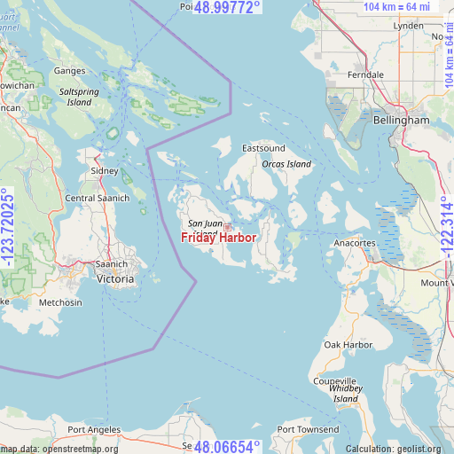
Friday Harbor GPS coordinates[2]
48° 32' 3.372" North, 123° 1' 1.632" West
| Map corner | latitude | longitude |
|---|---|---|
| Upper-left | 48.99772°, | -123.72025° |
| Center: | 48.53427°, | -123.01712° |
| Lower-right: | 48.06654°, | -122.314° |
| Map W x H: | 103.5×103.5 km | = 64.3×64.3mi |
| max Lat: | 71.29058° ⇑0.8% North |
| Friday Harbor: | 48.53427° |
| min Lat: | ⇓99.2% South 19.06759° |
| min Long | Friday Harbor | max Long |
| -171.73463° | -123.01712° | -66.98998° |
| W 2.1%⇐ | ⇒97.9% E |
Elevation
Elevation of Friday Harbor is 19 m = 62 ft, and this is 275.8 m = 905 ft below average elevation for this country.
| Max E: |
3189 m = 10463 ft | 88.6% |
| Avg. | 294.8 m = 967 ft | |
| Friday Harbor | 19 m = 62 ft | |
Min E: |
-60 m = -197 ft | 11.4% |
See also: United States elevation on elevation.city.
Geographical zone
Friday Harbor is located in North temperate zone (between Tropic of Cancer and the Arctic Circle). Distance of this North polar circle is 2004.7 km =1245.7 mi to North.| Distance of | km | miles | from Friday Harbor |
|---|---|---|---|
| North Pole | 4610.6 | 2864.9 | to North |
| Arctic Circle | 2004.7 | 1245.7 | to North |
| Tropic Cancer | 2790.6 | 1734 | to South |
| Equator | 5396.5 | 3353.2 | to South |


Nearby cities:
15 places around Friday Harbor: (largest is in red/bold)
• Anacortes
29.9 km =18.6 mi,  94°
94°
• Ault Field
33.4 km =20.8 mi,  130°
130°
• Bay View
40.1 km =24.9 mi,  98°
98°
• Bellingham
46.2 km =28.7 mi,  57°
57°
• Birch Bay
47.1 km =29.3 mi,  25°
25°
• Carlsborg
50.6 km =31.4 mi,  193°
193°
• Coupeville
42.7 km =26.5 mi,  145°
145°
• Ferndale
46.7 km =29 mi,  42°
42°
• La Conner
41.7 km =25.9 mi,  112°
112°
• Marietta
42.6 km =26.5 mi,  48°
48°
• Marietta-Alderwood
44.3 km =27.5 mi, 50°
• Oak Harbor
38.5 km =23.9 mi, 134°
• Point Roberts
50.4 km =31.3 mi,  354°
354°
• Port Townsend
50.1 km =31.1 mi,  157°
157°
• Sequim
50.9 km =31.6 mi, 187°
Sources, notices
• [Note1] Compared only with cities in United States existing in our database
• [Src1] Map data: © OpenStreetMap contributors (CC-BY-SA)
• [Src2] Other city data from geonames.org with taken over terms of usage.
• [Src3] Geographical zone / Annual Mean Temperature by Robert A. Rohde @ Wikipedia
