Burien geodata
Burien (Washington) is a populated place; located in United States in America/Los_Angeles (GMT-7) time zone. With population of 50,467 people, there are 941 cities with bigger population in this country. Compared to other cities in United States, 97.6% of cities are located further ↓South; 96.2% of cities are located further →East and 67.7% of cities have higher elevation than Burien. Note1


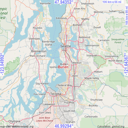
Burien GPS coordinates[2]
47° 28' 13.368" North, 122° 20' 48.444" West
| Map corner | latitude | longitude |
|---|---|---|
| Upper-left | 47.94352°, | -123.04992° |
| Center: | 47.47038°, | -122.34679° |
| Lower-right: | 46.99294°, | -121.64367° |
| Map W x H: | 105.7×105.7 km | = 65.7×65.7mi |
| max Lat: | 71.29058° ⇑2.4% North |
| Burien: | 47.47038° |
| min Lat: | ⇓97.6% South 19.06759° |
| min Long | Burien | max Long |
| -171.73463° | -122.34679° | -66.98998° |
| W 3.8%⇐ | ⇒96.2% E |
Elevation
Elevation of Burien is 114 m = 374 ft, and this is 180.8 m = 593 ft below average elevation for this country.
| Max E: |
3189 m = 10463 ft | 67.7% |
| Avg. | 294.8 m = 967 ft | |
| Burien | 114 m = 374 ft | |
Min E: |
-60 m = -197 ft | 32.3% |
See also: Burien elevation on elevation.city.
Geographical zone
Burien is located in North temperate zone (between Tropic of Cancer and the Arctic Circle). Distance of this North polar circle is 2123 km =1319.2 mi to North.| Distance of | km | miles | from Burien |
|---|---|---|---|
| North Pole | 4728.9 | 2938.4 | to North |
| Arctic Circle | 2123 | 1319.2 | to North |
| Tropic Cancer | 2672.3 | 1660.5 | to South |
| Equator | 5278.2 | 3279.7 | to South |


Nearby cities:
15 places around Burien: (largest is in red/bold)
• Boulevard Park
3.2 km =2 mi,  48°
48°
• Bryn Mawr-Skyway
8.4 km =5.2 mi,  71°
71°
• Des Moines
7.8 km =4.8 mi,  167°
167°
• Fairwood
14.4 km =8.9 mi,  99°
99°
• Kent
13 km =8.1 mi,  139°
139°
• Klahanie
8 km =5 mi,  237°
237°
• Mercer Island
14.6 km =9.1 mi,  40°
40°
• Normandy Park
3.8 km =2.4 mi, 173°
• Renton
9.8 km =6.1 mi,  81°
81°
• Riverton
4.2 km =2.6 mi, 68°
• SeaTac
4.8 km =3 mi,  120°
120°
• Southworth
12.5 km =7.8 mi,  291°
291°
• Tukwila
6.5 km =4 mi,  86°
86°
• Vashon
8.9 km =5.5 mi,  253°
253°
• White Center
5.3 km =3.3 mi,  353°
353°
Sources, notices
• [Note1] Compared only with cities in United States existing in our database
• [Src1] Map data: © OpenStreetMap contributors (CC-BY-SA)
• [Src2] Other city data from geonames.org with taken over terms of usage.
• [Src3] Geographical zone / Annual Mean Temperature by Robert A. Rohde @ Wikipedia
