White Center geodata
White Center (Washington) is a populated place; located in United States in America/Los_Angeles (GMT-7) time zone. With population of 13,495 people, there are 3556 cities with bigger population in this country. Compared to other cities in United States, 97.7% of cities are located further ↓South; 96.2% of cities are located further →East and 67.3% of cities have higher elevation than White Center. Note1


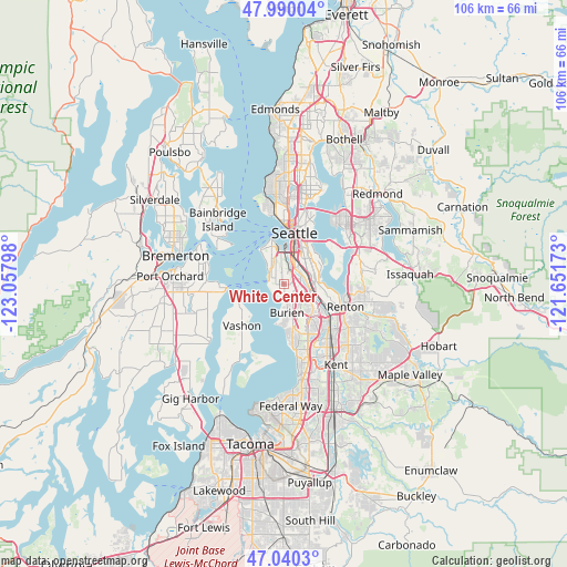
White Center GPS coordinates[2]
47° 31' 2.352" North, 122° 21' 17.46" West
| Map corner | latitude | longitude |
|---|---|---|
| Upper-left | 47.99004°, | -123.05798° |
| Center: | 47.51732°, | -122.35485° |
| Lower-right: | 47.0403°, | -121.65173° |
| Map W x H: | 105.6×105.6 km | = 65.6×65.6mi |
| max Lat: | 71.29058° ⇑2.3% North |
| White Center: | 47.51732° |
| min Lat: | ⇓97.7% South 19.06759° |
| min Long | White Center | max Long |
| -171.73463° | -122.35485° | -66.98998° |
| W 3.8%⇐ | ⇒96.2% E |
Elevation
Elevation of White Center is 116 m = 381 ft, and this is 178.8 m = 587 ft below average elevation for this country.
| Max E: |
3189 m = 10463 ft | 67.3% |
| Avg. | 294.8 m = 967 ft | |
| White Center | 116 m = 381 ft | |
Min E: |
-60 m = -197 ft | 32.7% |
See also: United States elevation on elevation.city.
Geographical zone
White Center is located in North temperate zone (between Tropic of Cancer and the Arctic Circle). Distance of this North polar circle is 2117.7 km =1315.9 mi to North.| Distance of | km | miles | from White Center |
|---|---|---|---|
| North Pole | 4723.6 | 2935.1 | to North |
| Arctic Circle | 2117.7 | 1315.9 | to North |
| Tropic Cancer | 2677.5 | 1663.7 | to South |
| Equator | 5283.4 | 3283 | to South |


Nearby cities:
15 places around White Center: (largest is in red/bold)
• Boulevard Park
4.3 km =2.7 mi,  136°
136°
• Bryn Mawr-Skyway
8.9 km =5.5 mi,  106°
106°
• Burien
5.3 km =3.3 mi,  173°
173°
• Des Moines
13.1 km =8.1 mi, 169°
• Klahanie
11.4 km =7.1 mi,  212°
212°
• Mercer Island
11.6 km =7.2 mi,  59°
59°
• Newport
14.4 km =8.9 mi,  65°
65°
• Normandy Park
9.1 km =5.7 mi, 173°
• Renton
11 km =6.8 mi, 110°
• Riverton
5.8 km =3.6 mi,  129°
129°
• SeaTac
9 km =5.6 mi,  148°
148°
• Seattle
10 km =6.2 mi,  9°
9°
• Southworth
11.1 km =6.9 mi,  266°
266°
• Tukwila
8.5 km =5.3 mi,  124°
124°
• Vashon
11.1 km =6.9 mi,  225°
225°
Sources, notices
• [Note1] Compared only with cities in United States existing in our database
• [Src1] Map data: © OpenStreetMap contributors (CC-BY-SA)
• [Src2] Other city data from geonames.org with taken over terms of usage.
• [Src3] Geographical zone / Annual Mean Temperature by Robert A. Rohde @ Wikipedia
