Mercer Island geodata
Mercer Island (Washington) is a populated place; located in United States in America/Los_Angeles (GMT-7) time zone. With population of 25,042 people, there are 2000 cities with bigger population in this country. Compared to other cities in United States, 97.8% of cities are located further ↓South; 95.7% of cities are located further →East and 69.6% of cities have higher elevation than Mercer Island. Note1


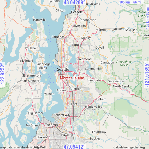
Mercer Island GPS coordinates[2]
47° 34' 14.34" North, 122° 13' 19.452" West
| Map corner | latitude | longitude |
|---|---|---|
| Upper-left | 48.04289°, | -122.9252° |
| Center: | 47.57065°, | -122.22207° |
| Lower-right: | 47.09412°, | -121.51895° |
| Map W x H: | 105.5×105.5 km | = 65.6×65.6mi |
| max Lat: | 71.29058° ⇑2.2% North |
| Mercer Island: | 47.57065° |
| min Lat: | ⇓97.8% South 19.06759° |
| min Long | Mercer Island | max Long |
| -171.73463° | -122.22207° | -66.98998° |
| W 4.3%⇐ | ⇒95.7% E |
Elevation
Elevation of Mercer Island is 103 m = 338 ft, and this is 191.8 m = 629 ft below average elevation for this country.
| Max E: |
3189 m = 10463 ft | 69.6% |
| Avg. | 294.8 m = 967 ft | |
| Mercer Island | 103 m = 338 ft | |
Min E: |
-60 m = -197 ft | 30.4% |
See also: United States elevation on elevation.city.
Geographical zone
Mercer Island is located in North temperate zone (between Tropic of Cancer and the Arctic Circle). Distance of this North polar circle is 2111.8 km =1312.2 mi to North.| Distance of | km | miles | from Mercer Island |
|---|---|---|---|
| North Pole | 4717.7 | 2931.4 | to North |
| Arctic Circle | 2111.8 | 1312.2 | to North |
| Tropic Cancer | 2683.4 | 1667.4 | to South |
| Equator | 5289.4 | 3286.7 | to South |


Nearby cities:
15 places around Mercer Island: (largest is in red/bold)
• Bellevue
4.7 km =2.9 mi,  19°
19°
• Boulevard Park
11.4 km =7.1 mi,  217°
217°
• Bryn Mawr-Skyway
8.6 km =5.3 mi,  189°
189°
• Clyde Hill
6.8 km =4.2 mi,  2°
2°
• Eastgate
5.7 km =3.5 mi,  87°
87°
• Medina
5.6 km =3.5 mi,  355°
355°
• Newcastle
6.1 km =3.8 mi,  125°
125°
• Newport
3.1 km =1.9 mi, 88°
• Renton
9.8 km =6.1 mi,  177°
177°
• Riverton
11 km =6.8 mi,  209°
209°
• Seattle
9.1 km =5.7 mi,  295°
295°
• Tukwila
11.1 km =6.9 mi,  195°
195°
• West Lake Sammamish
9.1 km =5.7 mi, 85°
• White Center
11.6 km =7.2 mi,  239°
239°
• Yarrow Point
8.4 km =5.2 mi, 2°
Sources, notices
• [Note1] Compared only with cities in United States existing in our database
• [Src1] Map data: © OpenStreetMap contributors (CC-BY-SA)
• [Src2] Other city data from geonames.org with taken over terms of usage.
• [Src3] Geographical zone / Annual Mean Temperature by Robert A. Rohde @ Wikipedia
