Connell geodata
Connell (Washington) is a populated place; located in United States in America/Los_Angeles (GMT-7) time zone. With population of 5,446 people, there are 6806 cities with bigger population in this country. Compared to other cities in United States, 96.1% of cities are located further ↓South; 91.8% of cities are located further →East and 63.5% of cities have lower elevation than Connell. Note1


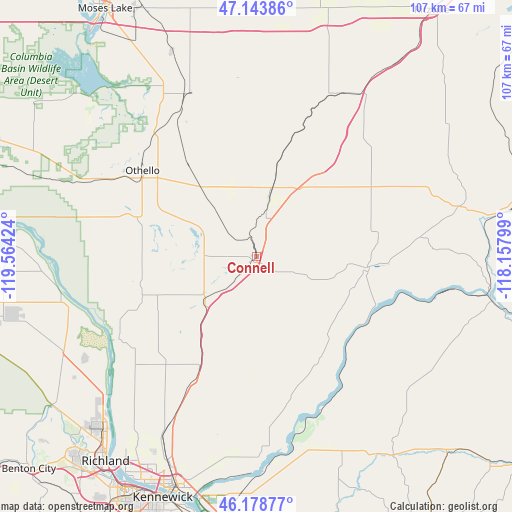
Connell GPS coordinates[2]
46° 39' 48.492" North, 118° 51' 39.996" West
| Map corner | latitude | longitude |
|---|---|---|
| Upper-left | 47.14386°, | -119.56424° |
| Center: | 46.66347°, | -118.86111° |
| Lower-right: | 46.17877°, | -118.15799° |
| Map W x H: | 107.3×107.3 km | = 66.7×66.7mi |
| max Lat: | 71.29058° ⇑3.9% North |
| Connell: | 46.66347° |
| min Lat: | ⇓96.1% South 19.06759° |
| min Long | Connell | max Long |
| -171.73463° | -118.86111° | -66.98998° |
| W 8.2%⇐ | ⇒91.8% E |
Elevation
Elevation of Connell is 255 m = 837 ft, and this is 39.8 m = 131 ft below average elevation for this country.
| Max E: |
3189 m = 10463 ft | 36.5% |
| Avg. | 294.8 m = 967 ft | |
| Connell | 255 m = 837 ft | |
Min E: |
-60 m = -197 ft | 63.5% |
See also: United States elevation on elevation.city.
Geographical zone
Connell is located in North temperate zone (between Tropic of Cancer and the Arctic Circle). Distance of this North polar circle is 2212.7 km =1374.9 mi to North.| Distance of | km | miles | from Connell |
|---|---|---|---|
| North Pole | 4818.6 | 2994.1 | to North |
| Arctic Circle | 2212.7 | 1374.9 | to North |
| Tropic Cancer | 2582.6 | 1604.8 | to South |
| Equator | 5188.5 | 3224 | to South |


Nearby cities:
15 places around Connell: (largest is in red/bold)
• Basin City
23.5 km =14.6 mi,  250°
250°
• Burbank
52.8 km =32.8 mi,  192°
192°
• Cascade Valley
63.3 km =39.3 mi,  325°
325°
• Finley
58.2 km =36.2 mi, 193°
• Highland
62.2 km =38.6 mi,  198°
198°
• Kennewick
54.6 km =33.9 mi, 202°
• Lind
39.1 km =24.3 mi,  28°
28°
• Moses Lake
60.8 km =37.8 mi, 328°
• Othello
30 km =18.6 mi,  307°
307°
• Pasco
50.6 km =31.4 mi, 201°
• Richland
53.1 km =33 mi,  217°
217°
• Ritzville
63.2 km =39.3 mi,  35°
35°
• Warden
36.4 km =22.6 mi,  338°
338°
• West Pasco
52.6 km =32.7 mi,  207°
207°
• West Richland
55.3 km =34.4 mi, 223°
Sources, notices
• [Note1] Compared only with cities in United States existing in our database
• [Src1] Map data: © OpenStreetMap contributors (CC-BY-SA)
• [Src2] Other city data from geonames.org with taken over terms of usage.
• [Src3] Geographical zone / Annual Mean Temperature by Robert A. Rohde @ Wikipedia
