Pasco geodata
Pasco (Washington) is a seat of a second-order administrative division; located in United States in America/Los_Angeles (GMT-7) time zone. With population of 69,451 people, there are 598 cities with bigger population in this country. Compared to other cities in United States, 95.4% of cities are located further ↓South; 92% of cities are located further →East and 67.5% of cities have higher elevation than Pasco. Note1


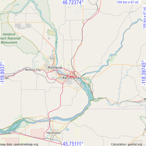
Pasco GPS coordinates[2]
46° 14' 22.488" North, 119° 6' 2.052" West
| Map corner | latitude | longitude |
|---|---|---|
| Upper-left | 46.72374°, | -119.8037° |
| Center: | 46.23958°, | -119.10057° |
| Lower-right: | 45.75111°, | -118.39745° |
| Map W x H: | 108.1×108.1 km | = 67.2×67.2mi |
| max Lat: | 71.29058° ⇑4.6% North |
| Pasco: | 46.23958° |
| min Lat: | ⇓95.4% South 19.06759° |
| min Long | Pasco | max Long |
| -171.73463° | -119.10057° | -66.98998° |
| W 8%⇐ | ⇒92% E |
Elevation
Elevation of Pasco is 115 m = 377 ft, and this is 179.8 m = 590 ft below average elevation for this country.
| Max E: |
3189 m = 10463 ft | 67.5% |
| Avg. | 294.8 m = 967 ft | |
| Pasco | 115 m = 377 ft | |
Min E: |
-60 m = -197 ft | 32.5% |
See also: Pasco elevation on elevation.city.
Geographical zone
Pasco is located in North temperate zone (between Tropic of Cancer and the Arctic Circle). Distance of this North polar circle is 2259.8 km =1404.2 mi to North.| Distance of | km | miles | from Pasco |
|---|---|---|---|
| North Pole | 4865.7 | 3023.4 | to North |
| Arctic Circle | 2259.8 | 1404.2 | to North |
| Tropic Cancer | 2535.4 | 1575.4 | to South |
| Equator | 5141.4 | 3194.7 | to South |


Nearby cities:
15 places around Pasco: (largest is in red/bold)
• Basin City
39.6 km =24.6 mi,  354°
354°
• Benton City
29.9 km =18.6 mi,  275°
275°
• Burbank
8.1 km =5 mi,  123°
123°
• Connell
50.6 km =31.4 mi,  21°
21°
• Finley
10.8 km =6.7 mi,  151°
151°
• Hermiston
46.7 km =29 mi,  198°
198°
• Highland
12.1 km =7.5 mi,  184°
184°
• Irrigon
48.7 km =30.3 mi,  218°
218°
• Kennewick
4.2 km =2.6 mi, 221°
• Prosser
51.5 km =32 mi,  265°
265°
• Richland
15 km =9.3 mi,  289°
289°
• Stanfield
51.8 km =32.2 mi,  190°
190°
• Umatilla
40.4 km =25.1 mi,  207°
207°
• West Pasco
6.4 km =4 mi, 275°
• West Richland
21.3 km =13.2 mi, 289°
Sources, notices
• [Note1] Compared only with cities in United States existing in our database
• [Src1] Map data: © OpenStreetMap contributors (CC-BY-SA)
• [Src2] Other city data from geonames.org with taken over terms of usage.
• [Src3] Geographical zone / Annual Mean Temperature by Robert A. Rohde @ Wikipedia
