Richland geodata
Richland (Washington) is a populated place; located in United States in America/Los_Angeles (GMT-7) time zone. With population of 54,248 people, there are 858 cities with bigger population in this country. Compared to other cities in United States, 95.5% of cities are located further ↓South; 92.2% of cities are located further →East and 67.5% of cities have higher elevation than Richland. Note1


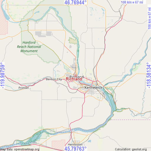
Richland GPS coordinates[2]
46° 17' 8.484" North, 119° 17' 4.056" West
| Map corner | latitude | longitude |
|---|---|---|
| Upper-left | 46.76944°, | -119.98759° |
| Center: | 46.28569°, | -119.28446° |
| Lower-right: | 45.79763°, | -118.58134° |
| Map W x H: | 108.1×108.1 km | = 67.2×67.2mi |
| max Lat: | 71.29058° ⇑4.5% North |
| Richland: | 46.28569° |
| min Lat: | ⇓95.5% South 19.06759° |
| min Long | Richland | max Long |
| -171.73463° | -119.28446° | -66.98998° |
| W 7.8%⇐ | ⇒92.2% E |
Elevation
Elevation of Richland is 115 m = 377 ft, and this is 179.8 m = 590 ft below average elevation for this country.
| Max E: |
3189 m = 10463 ft | 67.5% |
| Avg. | 294.8 m = 967 ft | |
| Richland | 115 m = 377 ft | |
Min E: |
-60 m = -197 ft | 32.5% |
See also: Richland elevation on elevation.city.
Geographical zone
Richland is located in North temperate zone (between Tropic of Cancer and the Arctic Circle). Distance of this North polar circle is 2254.7 km =1401 mi to North.| Distance of | km | miles | from Richland |
|---|---|---|---|
| North Pole | 4860.6 | 3020.2 | to North |
| Arctic Circle | 2254.7 | 1401 | to North |
| Tropic Cancer | 2540.6 | 1578.7 | to South |
| Equator | 5146.5 | 3197.9 | to South |


Nearby cities:
15 places around Richland: (largest is in red/bold)
• Basin City
35.7 km =22.2 mi,  16°
16°
• Benton City
15.8 km =9.8 mi,  260°
260°
• Burbank
22.9 km =14.2 mi,  114°
114°
• Connell
53.1 km =33 mi,  37°
37°
• Finley
24.2 km =15 mi,  127°
127°
• Grandview
47.6 km =29.6 mi,  265°
265°
• Hermiston
49.5 km =30.8 mi,  180°
180°
• Highland
21.6 km =13.4 mi,  142°
142°
• Irrigon
46.2 km =28.7 mi,  200°
200°
• Kennewick
14 km =8.7 mi, 126°
• Pasco
15 km =9.3 mi, 109°
• Prosser
38.3 km =23.8 mi, 256°
• Umatilla
41.2 km =25.6 mi,  186°
186°
• West Pasco
9 km =5.6 mi,  119°
119°
• West Richland
6.3 km =3.9 mi,  289°
289°
Sources, notices
• [Note1] Compared only with cities in United States existing in our database
• [Src1] Map data: © OpenStreetMap contributors (CC-BY-SA)
• [Src2] Other city data from geonames.org with taken over terms of usage.
• [Src3] Geographical zone / Annual Mean Temperature by Robert A. Rohde @ Wikipedia
