West Richland geodata
West Richland (Washington) is a populated place; located in United States in America/Los_Angeles (GMT-7) time zone. With population of 13,746 people, there are 3492 cities with bigger population in this country. Compared to other cities in United States, 95.5% of cities are located further ↓South; 92.3% of cities are located further →East and 65.5% of cities have higher elevation than West Richland. Note1


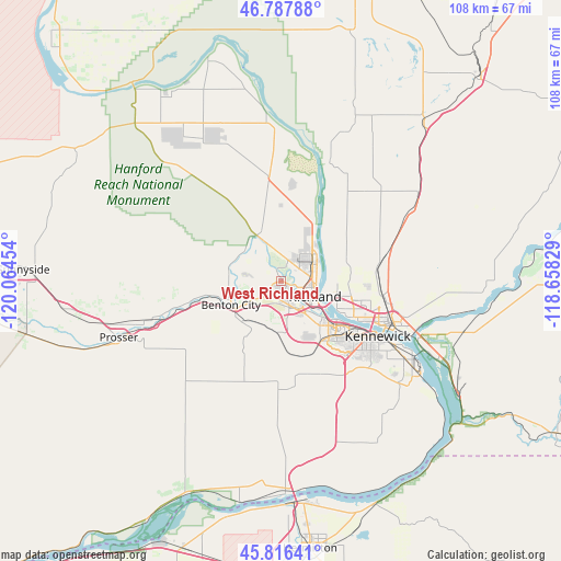
West Richland GPS coordinates[2]
46° 18' 15.48" North, 119° 21' 41.076" West
| Map corner | latitude | longitude |
|---|---|---|
| Upper-left | 46.78788°, | -120.06454° |
| Center: | 46.3043°, | -119.36141° |
| Lower-right: | 45.81641°, | -118.65829° |
| Map W x H: | 108×108 km | = 67.1×67.1mi |
| max Lat: | 71.29058° ⇑4.5% North |
| West Richland: | 46.3043° |
| min Lat: | ⇓95.5% South 19.06759° |
| min Long | West Richland | max Long |
| -171.73463° | -119.36141° | -66.98998° |
| W 7.7%⇐ | ⇒92.3% E |
Elevation
Elevation of West Richland is 126 m = 413 ft, and this is 168.8 m = 554 ft below average elevation for this country.
| Max E: |
3189 m = 10463 ft | 65.5% |
| Avg. | 294.8 m = 967 ft | |
| West Richland | 126 m = 413 ft | |
Min E: |
-60 m = -197 ft | 34.5% |
See also: United States elevation on elevation.city.
Geographical zone
West Richland is located in North temperate zone (between Tropic of Cancer and the Arctic Circle). Distance of this North polar circle is 2252.6 km =1399.7 mi to North.| Distance of | km | miles | from West Richland |
|---|---|---|---|
| North Pole | 4858.5 | 3018.9 | to North |
| Arctic Circle | 2252.6 | 1399.7 | to North |
| Tropic Cancer | 2542.6 | 1579.9 | to South |
| Equator | 5148.6 | 3199.2 | to South |


Nearby cities:
15 places around West Richland: (largest is in red/bold)
• Basin City
36 km =22.4 mi,  26°
26°
• Benton City
10.7 km =6.6 mi,  244°
244°
• Burbank
29.2 km =18.1 mi,  113°
113°
• Finley
30.2 km =18.8 mi,  123°
123°
• Grandview
41.9 km =26 mi,  261°
261°
• Highland
27 km =16.8 mi,  135°
135°
• Irrigon
46.5 km =28.9 mi,  192°
192°
• Kennewick
20.1 km =12.5 mi, 120°
• Mabton
49.8 km =30.9 mi, 258°
• Pasco
21.3 km =13.2 mi, 109°
• Prosser
33.2 km =20.6 mi,  250°
250°
• Richland
6.3 km =3.9 mi, 109°
• Sunnyside
49.8 km =30.9 mi,  272°
272°
• Umatilla
43 km =26.7 mi,  178°
178°
• West Pasco
15.2 km =9.4 mi, 115°
Sources, notices
• [Note1] Compared only with cities in United States existing in our database
• [Src1] Map data: © OpenStreetMap contributors (CC-BY-SA)
• [Src2] Other city data from geonames.org with taken over terms of usage.
• [Src3] Geographical zone / Annual Mean Temperature by Robert A. Rohde @ Wikipedia
