Kennewick geodata
Kennewick (Washington) is a populated place; located in United States in America/Los_Angeles (GMT-7) time zone. With population of 78,896 people, there are 504 cities with bigger population in this country. Compared to other cities in United States, 95.3% of cities are located further ↓South; 92% of cities are located further →East and 65.5% of cities have higher elevation than Kennewick. Note1


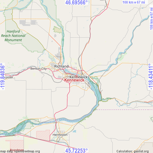
Kennewick GPS coordinates[2]
46° 12' 40.5" North, 119° 8' 14.028" West
| Map corner | latitude | longitude |
|---|---|---|
| Upper-left | 46.69566°, | -119.84036° |
| Center: | 46.21125°, | -119.13723° |
| Lower-right: | 45.72253°, | -118.43411° |
| Map W x H: | 108.2×108.2 km | = 67.2×67.2mi |
| max Lat: | 71.29058° ⇑4.7% North |
| Kennewick: | 46.21125° |
| min Lat: | ⇓95.3% South 19.06759° |
| min Long | Kennewick | max Long |
| -171.73463° | -119.13723° | -66.98998° |
| W 8%⇐ | ⇒92% E |
Elevation
Elevation of Kennewick is 126 m = 413 ft, and this is 168.8 m = 554 ft below average elevation for this country.
| Max E: |
3189 m = 10463 ft | 65.5% |
| Avg. | 294.8 m = 967 ft | |
| Kennewick | 126 m = 413 ft | |
Min E: |
-60 m = -197 ft | 34.5% |
See also: Kennewick elevation on elevation.city.
Geographical zone
Kennewick is located in North temperate zone (between Tropic of Cancer and the Arctic Circle). Distance of this North polar circle is 2263 km =1406.2 mi to North.| Distance of | km | miles | from Kennewick |
|---|---|---|---|
| North Pole | 4868.9 | 3025.4 | to North |
| Arctic Circle | 2263 | 1406.2 | to North |
| Tropic Cancer | 2532.3 | 1573.5 | to South |
| Equator | 5138.2 | 3192.7 | to South |


Nearby cities:
15 places around Kennewick: (largest is in red/bold)
• Basin City
42.6 km =26.5 mi,  358°
358°
• Benton City
27.6 km =17.1 mi,  282°
282°
• Burbank
9.6 km =6 mi,  97°
97°
• Echo
52.3 km =32.5 mi,  184°
184°
• Finley
10.2 km =6.3 mi,  128°
128°
• Hermiston
42.9 km =26.7 mi,  195°
195°
• Highland
9 km =5.6 mi,  168°
168°
• Irrigon
44.5 km =27.7 mi,  217°
217°
• Pasco
4.2 km =2.6 mi,  41°
41°
• Prosser
48.6 km =30.2 mi,  269°
269°
• Richland
14 km =8.7 mi,  306°
306°
• Stanfield
48.3 km =30 mi,  187°
187°
• Umatilla
36.3 km =22.6 mi,  205°
205°
• West Pasco
5.2 km =3.2 mi,  317°
317°
• West Richland
20.1 km =12.5 mi,  300°
300°
Sources, notices
• [Note1] Compared only with cities in United States existing in our database
• [Src1] Map data: © OpenStreetMap contributors (CC-BY-SA)
• [Src2] Other city data from geonames.org with taken over terms of usage.
• [Src3] Geographical zone / Annual Mean Temperature by Robert A. Rohde @ Wikipedia
