Ellensburg geodata
Ellensburg (Washington) is a seat of a second-order administrative division; located in United States in America/Los_Angeles (GMT-7) time zone. With population of 19,001 people, there are 2652 cities with bigger population in this country. Compared to other cities in United States, 96.6% of cities are located further ↓South; 93.3% of cities are located further →East and 87% of cities have lower elevation than Ellensburg. Note1


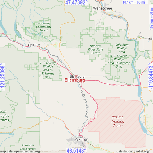
Ellensburg GPS coordinates[2]
46° 59' 47.436" North, 120° 32' 52.26" West
| Map corner | latitude | longitude |
|---|---|---|
| Upper-left | 47.47392°, | -121.25098° |
| Center: | 46.99651°, | -120.54785° |
| Lower-right: | 46.5148°, | -119.84473° |
| Map W x H: | 106.6×106.6 km | = 66.2×66.2mi |
| max Lat: | 71.29058° ⇑3.4% North |
| Ellensburg: | 46.99651° |
| min Lat: | ⇓96.6% South 19.06759° |
| min Long | Ellensburg | max Long |
| -171.73463° | -120.54785° | -66.98998° |
| W 6.7%⇐ | ⇒93.3% E |
Elevation
Elevation of Ellensburg is 468 m = 1535 ft, and this is 173.2 m = 568 ft above average elevation for this country.
| Max E: |
3189 m = 10463 ft | 13% |
| Ellensburg | 468 m 1535 ft | |
| Avg. | 294.8 m = 967 ft | |
Min E: |
-60 m = -197 ft | 87% |
See also: United States elevation on elevation.city.
Geographical zone
Ellensburg is located in North temperate zone (between Tropic of Cancer and the Arctic Circle). Distance of this North polar circle is 2175.7 km =1351.9 mi to North.| Distance of | km | miles | from Ellensburg |
|---|---|---|---|
| North Pole | 4781.5 | 2971.1 | to North |
| Arctic Circle | 2175.7 | 1351.9 | to North |
| Tropic Cancer | 2619.6 | 1627.7 | to South |
| Equator | 5225.5 | 3247 | to South |


Nearby cities:
15 places around Ellensburg: (largest is in red/bold)
• Ahtanum
48.9 km =30.4 mi,  186°
186°
• Cle Elum
37 km =23 mi,  306°
306°
• Gleed
37.9 km =23.5 mi, 187°
• Kittitas
10 km =6.2 mi,  98°
98°
• Naches
31.7 km =19.7 mi,  201°
201°
• Roslyn
42.1 km =26.2 mi, 306°
• Selah
38.1 km =23.7 mi,  177°
177°
• South Cle Elum
36.9 km =22.9 mi,  304°
304°
• South Wenatchee
47.9 km =29.8 mi,  24°
24°
• Summitview
45 km =28 mi, 189°
• Terrace Heights
44.2 km =27.5 mi,  169°
169°
• Tieton
36.3 km =22.6 mi,  205°
205°
• Union Gap
49.1 km =30.5 mi, 173°
• West Valley
45.2 km =28.1 mi, 185°
• Yakima
44 km =27.3 mi, 175°
Sources, notices
• [Note1] Compared only with cities in United States existing in our database
• [Src1] Map data: © OpenStreetMap contributors (CC-BY-SA)
• [Src2] Other city data from geonames.org with taken over terms of usage.
• [Src3] Geographical zone / Annual Mean Temperature by Robert A. Rohde @ Wikipedia
