Seattle geodata
Seattle (Washington) is a seat of a second-order administrative division; located in United States in America/Los_Angeles (GMT-7) time zone. With population of 684,451 people, there are 21 cities with bigger population in this country. Compared to other cities in United States, 97.9% of cities are located further ↓South; 96.1% of cities are located further →East and 77.9% of cities have higher elevation than Seattle. Note1


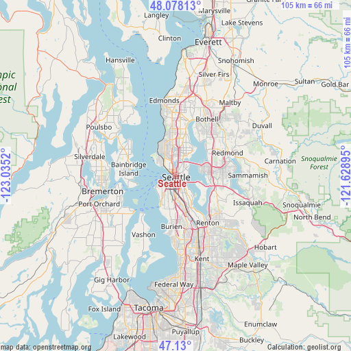
Seattle GPS coordinates[2]
47° 36' 22.356" North, 122° 19' 55.452" West
| Map corner | latitude | longitude |
|---|---|---|
| Upper-left | 48.07813°, | -123.0352° |
| Center: | 47.60621°, | -122.33207° |
| Lower-right: | 47.13°, | -121.62895° |
| Map W x H: | 105.4×105.4 km | = 65.5×65.5mi |
| max Lat: | 71.29058° ⇑2.1% North |
| Seattle: | 47.60621° |
| min Lat: | ⇓97.9% South 19.06759° |
| min Long | Seattle | max Long |
| -171.73463° | -122.33207° | -66.98998° |
| W 3.9%⇐ | ⇒96.1% E |
Elevation
Elevation of Seattle is 56 m = 184 ft, and this is 238.8 m = 783 ft below average elevation for this country.
| Max E: |
3189 m = 10463 ft | 77.9% |
| Avg. | 294.8 m = 967 ft | |
| Seattle | 56 m = 184 ft | |
Min E: |
-60 m = -197 ft | 22.1% |
See also: Seattle elevation on elevation.city.
Geographical zone
Seattle is located in North temperate zone (between Tropic of Cancer and the Arctic Circle). Distance of this North polar circle is 2107.9 km =1309.8 mi to North.| Distance of | km | miles | from Seattle |
|---|---|---|---|
| North Pole | 4713.7 | 2929 | to North |
| Arctic Circle | 2107.9 | 1309.8 | to North |
| Tropic Cancer | 2687.4 | 1669.9 | to South |
| Equator | 5293.3 | 3289.1 | to South |


Nearby cities:
15 places around Seattle: (largest is in red/bold)
• Bainbridge Island
14.4 km =8.9 mi,  278°
278°
• Bellevue
9.9 km =6.2 mi,  87°
87°
• Boulevard Park
13.1 km =8.1 mi,  174°
174°
• Bryn Mawr-Skyway
14.2 km =8.8 mi,  151°
151°
• Burien
15.1 km =9.4 mi,  184°
184°
• Clyde Hill
9 km =5.6 mi,  71°
71°
• Eastgate
14.5 km =9 mi,  104°
104°
• Inglewood-Finn Hill
14.8 km =9.2 mi,  30°
30°
• Kirkland
12.5 km =7.8 mi,  47°
47°
• Medina
8 km =5 mi,  78°
78°
• Mercer Island
9.1 km =5.7 mi,  115°
115°
• Newport
12 km =7.5 mi,  108°
108°
• Riverton
13.8 km =8.6 mi, 168°
• White Center
10 km =6.2 mi,  189°
189°
• Yarrow Point
9.7 km =6 mi,  62°
62°
Sources, notices
• [Note1] Compared only with cities in United States existing in our database
• [Src1] Map data: © OpenStreetMap contributors (CC-BY-SA)
• [Src2] Other city data from geonames.org with taken over terms of usage.
• [Src3] Geographical zone / Annual Mean Temperature by Robert A. Rohde @ Wikipedia
