Bellevue geodata
Bellevue (Washington) is a populated place; located in United States in America/Los_Angeles (GMT-7) time zone. With population of 139,820 people, there are 216 cities with bigger population in this country. Compared to other cities in United States, 97.9% of cities are located further ↓South; 95.6% of cities are located further →East and 85.1% of cities have higher elevation than Bellevue. Note1


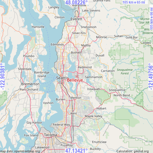
Bellevue GPS coordinates[2]
47° 36' 37.368" North, 122° 12' 2.448" West
| Map corner | latitude | longitude |
|---|---|---|
| Upper-left | 48.08226°, | -122.90381° |
| Center: | 47.61038°, | -122.20068° |
| Lower-right: | 47.13421°, | -121.49756° |
| Map W x H: | 105.4×105.4 km | = 65.5×65.5mi |
| max Lat: | 71.29058° ⇑2.1% North |
| Bellevue: | 47.61038° |
| min Lat: | ⇓97.9% South 19.06759° |
| min Long | Bellevue | max Long |
| -171.73463° | -122.20068° | -66.98998° |
| W 4.4%⇐ | ⇒95.6% E |
Elevation
Elevation of Bellevue is 28 m = 92 ft, and this is 266.8 m = 875 ft below average elevation for this country.
| Max E: |
3189 m = 10463 ft | 85.1% |
| Avg. | 294.8 m = 967 ft | |
| Bellevue | 28 m = 92 ft | |
Min E: |
-60 m = -197 ft | 14.9% |
See also: Bellevue elevation on elevation.city.
Geographical zone
Bellevue is located in North temperate zone (between Tropic of Cancer and the Arctic Circle). Distance of this North polar circle is 2107.4 km =1309.5 mi to North.| Distance of | km | miles | from Bellevue |
|---|---|---|---|
| North Pole | 4713.3 | 2928.7 | to North |
| Arctic Circle | 2107.4 | 1309.5 | to North |
| Tropic Cancer | 2687.9 | 1670.2 | to South |
| Equator | 5293.8 | 3289.4 | to South |


Nearby cities:
15 places around Bellevue: (largest is in red/bold)
• City of Sammamish
12.2 km =7.6 mi,  93°
93°
• Clyde Hill
2.7 km =1.7 mi,  331°
331°
• Eastgate
5.9 km =3.7 mi,  135°
135°
• Inglewood-Finn Hill
12.5 km =7.8 mi,  349°
349°
• Kingsgate
13.1 km =8.1 mi,  6°
6°
• Kirkland
7.9 km =4.9 mi,  355°
355°
• Medina
2.3 km =1.4 mi,  300°
300°
• Mercer Island
4.7 km =2.9 mi,  199°
199°
• Newcastle
8.6 km =5.3 mi,  156°
156°
• Newport
4.6 km =2.9 mi, 160°
• Redmond
9.2 km =5.7 mi,  39°
39°
• Sammamish
9.7 km =6 mi,  68°
68°
• Seattle
9.9 km =6.2 mi,  267°
267°
• West Lake Sammamish
8.3 km =5.2 mi,  116°
116°
• Yarrow Point
4.2 km =2.6 mi,  342°
342°
Sources, notices
• [Note1] Compared only with cities in United States existing in our database
• [Src1] Map data: © OpenStreetMap contributors (CC-BY-SA)
• [Src2] Other city data from geonames.org with taken over terms of usage.
• [Src3] Geographical zone / Annual Mean Temperature by Robert A. Rohde @ Wikipedia
