Sammamish geodata
Sammamish (Washington) is a populated place; located in United States in America/Los_Angeles (GMT-7) time zone. With population of 52,253 people, there are 901 cities with bigger population in this country. Compared to other cities in United States, 97.9% of cities are located further ↓South; 95.3% of cities are located further →East and 87% of cities have higher elevation than Sammamish. Note1


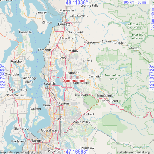
Sammamish GPS coordinates[2]
47° 38' 30.372" North, 122° 4' 49.44" West
| Map corner | latitude | longitude |
|---|---|---|
| Upper-left | 48.11336°, | -122.78353° |
| Center: | 47.64177°, | -122.0804° |
| Lower-right: | 47.16588°, | -121.37728° |
| Map W x H: | 105.3×105.3 km | = 65.4×65.4mi |
| max Lat: | 71.29058° ⇑2.1% North |
| Sammamish: | 47.64177° |
| min Lat: | ⇓97.9% South 19.06759° |
| min Long | Sammamish | max Long |
| -171.73463° | -122.0804° | -66.98998° |
| W 4.7%⇐ | ⇒95.3% E |
Elevation
Elevation of Sammamish is 23 m = 75 ft, and this is 271.8 m = 892 ft below average elevation for this country.
| Max E: |
3189 m = 10463 ft | 87% |
| Avg. | 294.8 m = 967 ft | |
| Sammamish | 23 m = 75 ft | |
Min E: |
-60 m = -197 ft | 13% |
See also: Sammamish elevation on elevation.city.
Geographical zone
Sammamish is located in North temperate zone (between Tropic of Cancer and the Arctic Circle). Distance of this North polar circle is 2103.9 km =1307.3 mi to North.| Distance of | km | miles | from Sammamish |
|---|---|---|---|
| North Pole | 4709.8 | 2926.5 | to North |
| Arctic Circle | 2103.9 | 1307.3 | to North |
| Tropic Cancer | 2691.3 | 1672.3 | to South |
| Equator | 5297.3 | 3291.6 | to South |


Nearby cities:
15 places around Sammamish: (largest is in red/bold)
• Ames Lake
8.6 km =5.3 mi,  96°
96°
• Bellevue
9.7 km =6 mi,  248°
248°
• City of Sammamish
5.2 km =3.2 mi,  142°
142°
• Clyde Hill
10.4 km =6.5 mi,  263°
263°
• Cottage Lake
11.4 km =7.1 mi,  1°
1°
• Eastgate
9.1 km =5.7 mi,  212°
212°
• Kingsgate
12 km =7.5 mi,  321°
321°
• Kirkland
10.6 km =6.6 mi,  294°
294°
• Klahanie
9.5 km =5.9 mi,  145°
145°
• Medina
11.3 km =7 mi, 258°
• Newport
10.9 km =6.8 mi,  223°
223°
• Redmond
4.7 km =2.9 mi, 319°
• Union Hill-Novelty Hill
5.7 km =3.5 mi,  43°
43°
• West Lake Sammamish
7.3 km =4.5 mi,  192°
192°
• Yarrow Point
10.3 km =6.4 mi,  272°
272°
Sources, notices
• [Note1] Compared only with cities in United States existing in our database
• [Src1] Map data: © OpenStreetMap contributors (CC-BY-SA)
• [Src2] Other city data from geonames.org with taken over terms of usage.
• [Src3] Geographical zone / Annual Mean Temperature by Robert A. Rohde @ Wikipedia
