Redmond geodata
Redmond (Washington) is a populated place; located in United States in America/Los_Angeles (GMT-7) time zone. With population of 60,598 people, there are 731 cities with bigger population in this country. Compared to other cities in United States, 98% of cities are located further ↓South; 95.4% of cities are located further →East and 90.5% of cities have higher elevation than Redmond. Note1


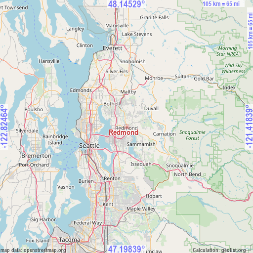
Redmond GPS coordinates[2]
47° 40' 26.364" North, 122° 7' 17.436" West
| Map corner | latitude | longitude |
|---|---|---|
| Upper-left | 48.14529°, | -122.82464° |
| Center: | 47.67399°, | -122.12151° |
| Lower-right: | 47.19839°, | -121.41839° |
| Map W x H: | 105.3×105.3 km | = 65.4×65.4mi |
| max Lat: | 71.29058° ⇑2% North |
| Redmond: | 47.67399° |
| min Lat: | ⇓98% South 19.06759° |
| min Long | Redmond | max Long |
| -171.73463° | -122.12151° | -66.98998° |
| W 4.6%⇐ | ⇒95.4% E |
Elevation
Elevation of Redmond is 15 m = 49 ft, and this is 279.8 m = 918 ft below average elevation for this country.
| Max E: |
3189 m = 10463 ft | 90.5% |
| Avg. | 294.8 m = 967 ft | |
| Redmond | 15 m = 49 ft | |
Min E: |
-60 m = -197 ft | 9.5% |
See also: Redmond elevation on elevation.city.
Geographical zone
Redmond is located in North temperate zone (between Tropic of Cancer and the Arctic Circle). Distance of this North polar circle is 2100.3 km =1305.1 mi to North.| Distance of | km | miles | from Redmond |
|---|---|---|---|
| North Pole | 4706.2 | 2924.3 | to North |
| Arctic Circle | 2100.3 | 1305.1 | to North |
| Tropic Cancer | 2694.9 | 1674.5 | to South |
| Equator | 5300.9 | 3293.8 | to South |


Nearby cities:
15 places around Redmond: (largest is in red/bold)
• Bellevue
9.2 km =5.7 mi,  219°
219°
• Bothell
11.7 km =7.3 mi,  327°
327°
• City of Sammamish
10 km =6.2 mi,  140°
140°
• Clyde Hill
8.6 km =5.3 mi,  236°
236°
• Cottage Lake
8.5 km =5.3 mi,  22°
22°
• Eastgate
11.4 km =7.1 mi,  189°
189°
• Inglewood-Finn Hill
9.7 km =6 mi,  302°
302°
• Kingsgate
7.3 km =4.5 mi,  323°
323°
• Kirkland
6.6 km =4.1 mi,  277°
277°
• Medina
9.9 km =6.2 mi,  233°
233°
• Sammamish
4.7 km =2.9 mi, 139°
• Union Hill-Novelty Hill
7 km =4.3 mi,  85°
85°
• West Lake Sammamish
10.8 km =6.7 mi,  171°
171°
• Woodinville
9.5 km =5.9 mi,  340°
340°
• Yarrow Point
7.8 km =4.8 mi,  246°
246°
Sources, notices
• [Note1] Compared only with cities in United States existing in our database
• [Src1] Map data: © OpenStreetMap contributors (CC-BY-SA)
• [Src2] Other city data from geonames.org with taken over terms of usage.
• [Src3] Geographical zone / Annual Mean Temperature by Robert A. Rohde @ Wikipedia
