Kirkland geodata
Kirkland (Washington) is a populated place; located in United States in America/Los_Angeles (GMT-7) time zone. With population of 87,281 people, there are 434 cities with bigger population in this country. Compared to other cities in United States, 98.1% of cities are located further ↓South; 95.7% of cities are located further →East and 78.8% of cities have higher elevation than Kirkland. Note1


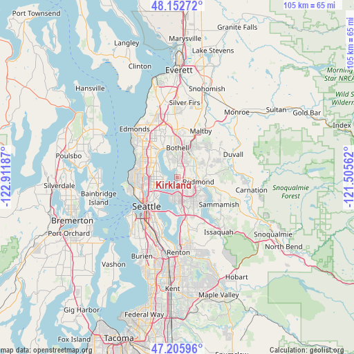
Kirkland GPS coordinates[2]
47° 40' 53.364" North, 122° 12' 31.464" West
| Map corner | latitude | longitude |
|---|---|---|
| Upper-left | 48.15272°, | -122.91187° |
| Center: | 47.68149°, | -122.20874° |
| Lower-right: | 47.20596°, | -121.50562° |
| Map W x H: | 105.3×105.3 km | = 65.4×65.4mi |
| max Lat: | 71.29058° ⇑1.9% North |
| Kirkland: | 47.68149° |
| min Lat: | ⇓98.1% South 19.06759° |
| min Long | Kirkland | max Long |
| -171.73463° | -122.20874° | -66.98998° |
| W 4.3%⇐ | ⇒95.7% E |
Elevation
Elevation of Kirkland is 52 m = 171 ft, and this is 242.8 m = 797 ft below average elevation for this country.
| Max E: |
3189 m = 10463 ft | 78.8% |
| Avg. | 294.8 m = 967 ft | |
| Kirkland | 52 m = 171 ft | |
Min E: |
-60 m = -197 ft | 21.2% |
See also: Kirkland elevation on elevation.city.
Geographical zone
Kirkland is located in North temperate zone (between Tropic of Cancer and the Arctic Circle). Distance of this North polar circle is 2099.5 km =1304.6 mi to North.| Distance of | km | miles | from Kirkland |
|---|---|---|---|
| North Pole | 4705.4 | 2923.8 | to North |
| Arctic Circle | 2099.5 | 1304.6 | to North |
| Tropic Cancer | 2695.8 | 1675.1 | to South |
| Equator | 5301.7 | 3294.3 | to South |


Nearby cities:
15 places around Kirkland: (largest is in red/bold)
• Bellevue
7.9 km =4.9 mi,  175°
175°
• Bothell
9 km =5.6 mi,  1°
1°
• Clyde Hill
5.6 km =3.5 mi,  187°
187°
• Cottage Lake
12.1 km =7.5 mi,  54°
54°
• Inglewood-Finn Hill
4.7 km =2.9 mi,  338°
338°
• Kenmore
8.8 km =5.5 mi, 342°
• Kingsgate
5.5 km =3.4 mi,  23°
23°
• Lake Forest Park
10 km =6.2 mi,  327°
327°
• Medina
6.9 km =4.3 mi, 191°
• Mercer Island
12.4 km =7.7 mi, 184°
• Newport
12.4 km =7.7 mi,  170°
170°
• Redmond
6.6 km =4.1 mi,  97°
97°
• Sammamish
10.6 km =6.6 mi,  114°
114°
• Woodinville
8.8 km =5.5 mi, 22°
• Yarrow Point
4 km =2.5 mi, 189°
Sources, notices
• [Note1] Compared only with cities in United States existing in our database
• [Src1] Map data: © OpenStreetMap contributors (CC-BY-SA)
• [Src2] Other city data from geonames.org with taken over terms of usage.
• [Src3] Geographical zone / Annual Mean Temperature by Robert A. Rohde @ Wikipedia
