Sunnyside geodata
Sunnyside (Washington) is a populated place; located in United States in America/Los_Angeles (GMT-7) time zone. With population of 16,325 people, there are 3008 cities with bigger population in this country. Compared to other cities in United States, 95.5% of cities are located further ↓South; 92.8% of cities are located further →East and 57.2% of cities have lower elevation than Sunnyside. Note1


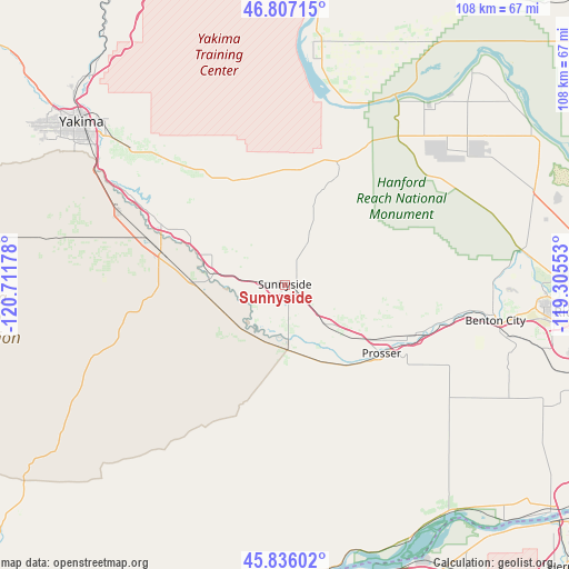
Sunnyside GPS coordinates[2]
46° 19' 25.464" North, 120° 0' 31.14" West
| Map corner | latitude | longitude |
|---|---|---|
| Upper-left | 46.80715°, | -120.71178° |
| Center: | 46.32374°, | -120.00865° |
| Lower-right: | 45.83602°, | -119.30553° |
| Map W x H: | 108×108 km | = 67.1×67.1mi |
| max Lat: | 71.29058° ⇑4.5% North |
| Sunnyside: | 46.32374° |
| min Lat: | ⇓95.5% South 19.06759° |
| min Long | Sunnyside | max Long |
| -171.73463° | -120.00865° | -66.98998° |
| W 7.2%⇐ | ⇒92.8% E |
Elevation
Elevation of Sunnyside is 227 m = 745 ft, and this is 67.8 m = 222 ft below average elevation for this country.
| Max E: |
3189 m = 10463 ft | 42.8% |
| Avg. | 294.8 m = 967 ft | |
| Sunnyside | 227 m = 745 ft | |
Min E: |
-60 m = -197 ft | 57.2% |
See also: United States elevation on elevation.city.
Geographical zone
Sunnyside is located in North temperate zone (between Tropic of Cancer and the Arctic Circle). Distance of this North polar circle is 2250.5 km =1398.4 mi to North.| Distance of | km | miles | from Sunnyside |
|---|---|---|---|
| North Pole | 4856.3 | 3017.6 | to North |
| Arctic Circle | 2250.5 | 1398.4 | to North |
| Tropic Cancer | 2544.8 | 1581.3 | to South |
| Equator | 5150.7 | 3200.5 | to South |


Nearby cities:
15 places around Sunnyside: (largest is in red/bold)
• Benton City
40.6 km =25.2 mi,  99°
99°
• Buena
26.1 km =16.2 mi,  296°
296°
• Desert Aire
40.1 km =24.9 mi,  10°
10°
• Grandview
11.5 km =7.1 mi,  134°
134°
• Granger
13.9 km =8.6 mi,  278°
278°
• Harrah
42.1 km =26.2 mi, 282°
• Mabton
12.1 km =7.5 mi,  175°
175°
• Moxee City
38.4 km =23.9 mi,  311°
311°
• Prosser
22.6 km =14 mi, 125°
• Satus
12.4 km =7.7 mi,  241°
241°
• Terrace Heights
45.6 km =28.3 mi, 313°
• Toppenish
23.8 km =14.8 mi, 284°
• Union Gap
44.2 km =27.5 mi, 306°
• Wapato
34.4 km =21.4 mi,  293°
293°
• Zillah
21.3 km =13.2 mi, 294°
Sources, notices
• [Note1] Compared only with cities in United States existing in our database
• [Src1] Map data: © OpenStreetMap contributors (CC-BY-SA)
• [Src2] Other city data from geonames.org with taken over terms of usage.
• [Src3] Geographical zone / Annual Mean Temperature by Robert A. Rohde @ Wikipedia
