Prosser geodata
Prosser (Washington) is a seat of a second-order administrative division; located in United States in America/Los_Angeles (GMT-7) time zone. With population of 5,869 people, there are 6497 cities with bigger population in this country. Compared to other cities in United States, 95.3% of cities are located further ↓South; 92.6% of cities are located further →East and 51.2% of cities have lower elevation than Prosser. Note1


Prosser GPS coordinates[2]
46° 12' 24.48" North, 119° 46' 8.112" West
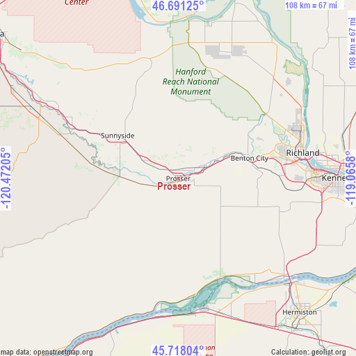
| Map corner | latitude | longitude |
|---|---|---|
| Upper-left | 46.69125°, | -120.47205° |
| Center: | 46.2068°, | -119.76892° |
| Lower-right: | 45.71804°, | -119.0658° |
| Map W x H: | 108.2×108.2 km | = 67.2×67.2mi |
| max Lat: | 71.29058° ⇑4.7% North |
| Prosser: | 46.2068° |
| min Lat: | ⇓95.3% South 19.06759° |
| min Long | Prosser | max Long |
| -171.73463° | -119.76892° | -66.98998° |
| W 7.4%⇐ | ⇒92.6% E |
Elevation
Elevation of Prosser is 203 m = 666 ft, and this is 91.8 m = 301 ft below average elevation for this country.
| Max E: |
3189 m = 10463 ft | 48.8% |
| Avg. | 294.8 m = 967 ft | |
| Prosser | 203 m = 666 ft | |
Min E: |
-60 m = -197 ft | 51.2% |
See also: United States elevation on elevation.city.
Geographical zone
Prosser is located in North temperate zone (between Tropic of Cancer and the Arctic Circle). Distance of this North polar circle is 2263.5 km =1406.5 mi to North.| Distance of | km | miles | from Prosser |
|---|---|---|---|
| North Pole | 4869.3 | 3025.6 | to North |
| Arctic Circle | 2263.5 | 1406.5 | to North |
| Tropic Cancer | 2531.8 | 1573.2 | to South |
| Equator | 5137.7 | 3192.4 | to South |


Nearby cities:
15 places around Prosser: (largest is in red/bold)
• Benton City
22.5 km =14 mi,  73°
73°
• Boardman
41.1 km =25.5 mi,  172°
172°
• Grandview
11.3 km =7 mi,  295°
295°
• Granger
35.5 km =22.1 mi, 295°
• Irrigon
40.7 km =25.3 mi,  148°
148°
• Kennewick
48.6 km =30.2 mi,  89°
89°
• Mabton
17.5 km =10.9 mi,  272°
272°
• Richland
38.3 km =23.8 mi,  76°
76°
• Satus
30.2 km =18.8 mi,  283°
283°
• Sunnyside
22.6 km =14 mi,  305°
305°
• Toppenish
45.6 km =28.3 mi,  294°
294°
• Umatilla
46 km =28.6 mi,  134°
134°
• West Pasco
45.3 km =28.1 mi, 84°
• West Richland
33.2 km =20.6 mi, 70°
• Zillah
43.7 km =27.2 mi, 299°
Sources, notices
• [Note1] Compared only with cities in United States existing in our database
• [Src1] Map data: © OpenStreetMap contributors (CC-BY-SA)
• [Src2] Other city data from geonames.org with taken over terms of usage.
• [Src3] Geographical zone / Annual Mean Temperature by Robert A. Rohde @ Wikipedia
