Mabton geodata
Mabton (Washington) is a populated place; located in United States in America/Los_Angeles (GMT-7) time zone. With population of 2,302 people, there are 11073 cities with bigger population in this country. Compared to other cities in United States, 95.3% of cities are located further ↓South; 92.8% of cities are located further →East and 54.9% of cities have lower elevation than Mabton. Note1


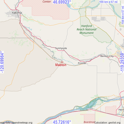
Mabton GPS coordinates[2]
46° 12' 53.46" North, 119° 59' 48.156" West
| Map corner | latitude | longitude |
|---|---|---|
| Upper-left | 46.69923°, | -120.69984° |
| Center: | 46.21485°, | -119.99671° |
| Lower-right: | 45.72616°, | -119.29359° |
| Map W x H: | 108.2×108.2 km | = 67.2×67.2mi |
| max Lat: | 71.29058° ⇑4.7% North |
| Mabton: | 46.21485° |
| min Lat: | ⇓95.3% South 19.06759° |
| min Long | Mabton | max Long |
| -171.73463° | -119.99671° | -66.98998° |
| W 7.2%⇐ | ⇒92.8% E |
Elevation
Elevation of Mabton is 218 m = 715 ft, and this is 76.8 m = 252 ft below average elevation for this country.
| Max E: |
3189 m = 10463 ft | 45.1% |
| Avg. | 294.8 m = 967 ft | |
| Mabton | 218 m = 715 ft | |
Min E: |
-60 m = -197 ft | 54.9% |
See also: United States elevation on elevation.city.
Geographical zone
Mabton is located in North temperate zone (between Tropic of Cancer and the Arctic Circle). Distance of this North polar circle is 2262.6 km =1405.9 mi to North.| Distance of | km | miles | from Mabton |
|---|---|---|---|
| North Pole | 4868.5 | 3025.1 | to North |
| Arctic Circle | 2262.6 | 1405.9 | to North |
| Tropic Cancer | 2532.7 | 1573.7 | to South |
| Equator | 5138.6 | 3193 | to South |


Nearby cities:
15 places around Mabton: (largest is in red/bold)
• Benton City
39.5 km =24.5 mi,  82°
82°
• Boardman
47.6 km =29.6 mi,  151°
151°
• Buena
34 km =21.1 mi,  314°
314°
• Desert Aire
52 km =32.3 mi,  6°
6°
• Grandview
8.3 km =5.2 mi,  61°
61°
• Granger
20.4 km =12.7 mi, 314°
• Harrah
47 km =29.2 mi,  296°
296°
• Moxee City
47.9 km =29.8 mi,  321°
321°
• Prosser
17.5 km =10.9 mi,  92°
92°
• Satus
13.3 km =8.3 mi, 297°
• Sunnyside
12.1 km =7.5 mi,  355°
355°
• Toppenish
30 km =18.6 mi, 307°
• Wapato
41.6 km =25.8 mi, 308°
• West Richland
49.8 km =30.9 mi, 78°
• Zillah
29.1 km =18.1 mi, 315°
Sources, notices
• [Note1] Compared only with cities in United States existing in our database
• [Src1] Map data: © OpenStreetMap contributors (CC-BY-SA)
• [Src2] Other city data from geonames.org with taken over terms of usage.
• [Src3] Geographical zone / Annual Mean Temperature by Robert A. Rohde @ Wikipedia
