Buffalo geodata
Buffalo (Wyoming) is a seat of a second-order administrative division; located in United States in America/Denver (GMT-6) time zone. With population of 4,632 people, there are 7513 cities with bigger population in this country. Compared to other cities in United States, 89.9% of cities are located further ↓South; 84.5% of cities are located further →East and 96.1% of cities have lower elevation than Buffalo. Note1


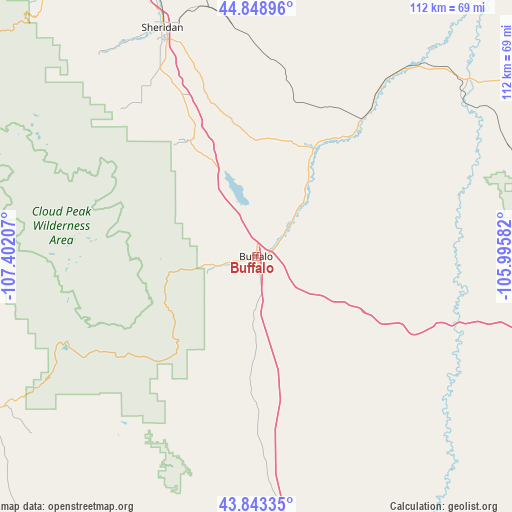
Buffalo GPS coordinates[2]
44° 20' 53.916" North, 106° 41' 56.184" West
| Map corner | latitude | longitude |
|---|---|---|
| Upper-left | 44.84896°, | -107.40207° |
| Center: | 44.34831°, | -106.69894° |
| Lower-right: | 43.84335°, | -105.99582° |
| Map W x H: | 111.8×111.8 km | = 69.5×69.5mi |
| max Lat: | 71.29058° ⇑10.1% North |
| Buffalo: | 44.34831° |
| min Lat: | ⇓89.9% South 19.06759° |
| min Long | Buffalo | max Long |
| -171.73463° | -106.69894° | -66.98998° |
| W 15.5%⇐ | ⇒84.5% E |
Elevation
Elevation of Buffalo is 1417 m = 4649 ft, and this is 1122.2 m = 3682 ft above average elevation for this country.
| Max E: |
3189 m = 10463 ft | 3.9% |
| Buffalo | 1417 m 4649 ft | |
| Avg. | 294.8 m = 967 ft | |
Min E: |
-60 m = -197 ft | 96.1% |
See also: United States elevation on elevation.city.
Geographical zone
Buffalo is located in North temperate zone (between Tropic of Cancer and the Arctic Circle). Distance of this Northern Tropic circle is 2325.2 km =1444.8 mi to South.| Distance of | km | miles | from Buffalo |
|---|---|---|---|
| North Pole | 5076 | 3154.1 | to North |
| Arctic Circle | 2470.1 | 1534.8 | to North |
| Tropic Cancer | 2325.2 | 1444.8 | to South |
| Equator | 4931.1 | 3064 | to South |


Nearby cities:
15 places around Buffalo: (largest is in red/bold)
• Antelope Valley-Crestview
98.5 km =61.2 mi,  98°
98°
• Basin
106.6 km =66.2 mi,  271°
271°
• Busby
133.7 km =83.1 mi,  351°
351°
• Dayton
73.6 km =45.7 mi,  322°
322°
• Gillette
95.4 km =59.3 mi,  93°
93°
• Greybull
108.9 km =67.7 mi,  278°
278°
• Lucerne
136.4 km =84.8 mi,  239°
239°
• Moorcroft
139.5 km =86.7 mi, 93°
• Ranchester
72.4 km =45 mi,  329°
329°
• Sheridan
53.9 km =33.5 mi,  337°
337°
• Sleepy Hollow
102.3 km =63.6 mi, 96°
• Story
29.3 km =18.2 mi, 329°
• Washakie Ten
100.4 km =62.4 mi,  253°
253°
• Worland
106.7 km =66.3 mi, 249°
• Wright
117.1 km =72.8 mi,  124°
124°
Sources, notices
• [Note1] Compared only with cities in United States existing in our database
• [Src1] Map data: © OpenStreetMap contributors (CC-BY-SA)
• [Src2] Other city data from geonames.org with taken over terms of usage.
• [Src3] Geographical zone / Annual Mean Temperature by Robert A. Rohde @ Wikipedia
