Wright geodata
Wright (Wyoming) is a populated place; located in United States in America/Denver (GMT-6) time zone. With population of 1,862 people, there are 12333 cities with bigger population in this country. Compared to other cities in United States, 87.4% of cities are located further ↓South; 83.6% of cities are located further →East and 96.8% of cities have lower elevation than Wright. Note1


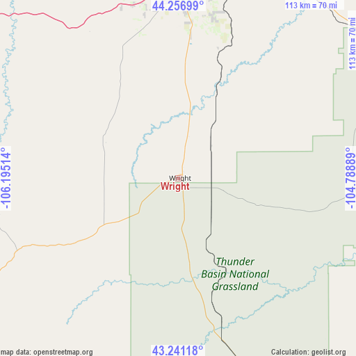
Wright GPS coordinates[2]
43° 45' 4.464" North, 105° 29' 31.236" West
| Map corner | latitude | longitude |
|---|---|---|
| Upper-left | 44.25699°, | -106.19514° |
| Center: | 43.75124°, | -105.49201° |
| Lower-right: | 43.24118°, | -104.78889° |
| Map W x H: | 112.9×112.9 km | = 70.2×70.2mi |
| max Lat: | 71.29058° ⇑12.6% North |
| Wright: | 43.75124° |
| min Lat: | ⇓87.4% South 19.06759° |
| min Long | Wright | max Long |
| -171.73463° | -105.49201° | -66.98998° |
| W 16.4%⇐ | ⇒83.6% E |
Elevation
Elevation of Wright is 1519 m = 4984 ft, and this is 1224.2 m = 4016 ft above average elevation for this country.
| Max E: |
3189 m = 10463 ft | 3.2% |
| Wright | 1519 m 4984 ft | |
| Avg. | 294.8 m = 967 ft | |
Min E: |
-60 m = -197 ft | 96.8% |
See also: United States elevation on elevation.city.
Geographical zone
Wright is located in North temperate zone (between Tropic of Cancer and the Arctic Circle). Distance of this Northern Tropic circle is 2258.8 km =1403.6 mi to South.| Distance of | km | miles | from Wright |
|---|---|---|---|
| North Pole | 5142.4 | 3195.3 | to North |
| Arctic Circle | 2536.5 | 1576.1 | to North |
| Tropic Cancer | 2258.8 | 1403.6 | to South |
| Equator | 4864.7 | 3022.8 | to South |


Nearby cities:
15 places around Wright: (largest is in red/bold)
• Antelope Valley-Crestview
52.7 km =32.7 mi,  1°
1°
• Bar Nunn
115.8 km =72 mi,  216°
216°
• Buffalo
117.1 km =72.8 mi,  304°
304°
• Casper
118.7 km =73.8 mi,  214°
214°
• Douglas
110.6 km =68.7 mi,  175°
175°
• Evansville
117.3 km =72.9 mi, 212°
• Gillette
60 km =37.3 mi,  359°
359°
• Glenrock
103.6 km =64.4 mi,  197°
197°
• Hartrandt
118.4 km =73.6 mi, 215°
• Moorcroft
71.5 km =44.4 mi,  37°
37°
• Newcastle
103.9 km =64.6 mi,  83°
83°
• Pine Haven
86.7 km =53.9 mi, 38°
• Sleepy Hollow
54.8 km =34.1 mi,  5°
5°
• Sundance
115.1 km =71.5 mi,  50°
50°
• Upton
79.3 km =49.3 mi,  60°
60°
Sources, notices
• [Note1] Compared only with cities in United States existing in our database
• [Src1] Map data: © OpenStreetMap contributors (CC-BY-SA)
• [Src2] Other city data from geonames.org with taken over terms of usage.
• [Src3] Geographical zone / Annual Mean Temperature by Robert A. Rohde @ Wikipedia
