Kailua-Kona geodata
Kailua-Kona (Hawaii) is a populated place; located in United States in Pacific/Honolulu (GMT-10) time zone. With population of 11,975 people, there are 3907 cities with bigger population in this country. Compared to other cities in United States, 99.9% of cities are located further ↑North; 99.4% of cities are located further →East and 98.1% of cities have higher elevation than Kailua-Kona. Note1


Kailua-Kona GPS coordinates[2]
19° 38' 24.576" North, 155° 59' 56.832" West
| Map corner | latitude | longitude |
|---|---|---|
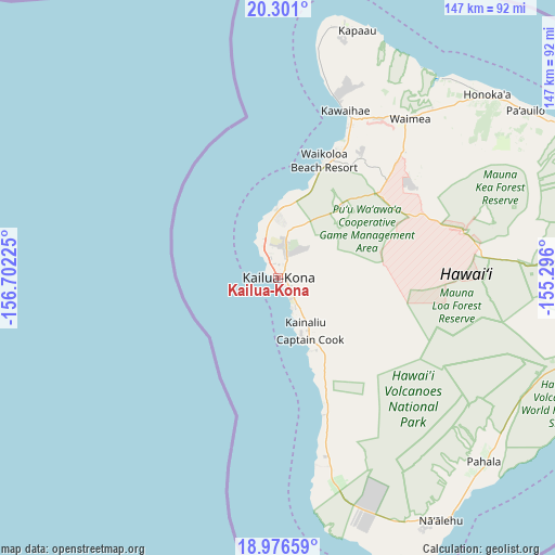
| Upper-left | 20.301°, | -156.70225° |
| Center: | 19.64016°, | -155.99912° |
| Lower-right: | 18.97659°, | -155.296° |
| Map W x H: | 147.3×147.3 km | = 91.5×91.5mi |
| max Lat: | 71.29058° ⇑99.9% North |
| Kailua-Kona: | 19.64016° |
| min Lat: | ⇓0.1% South 19.06759° |
| min Long | Kailua-Kona | max Long |
| -171.73463° | -155.99912° | -66.98998° |
| W 0.6%⇐ | ⇒99.4% E |
Elevation
Elevation of Kailua-Kona is 5 m = 16 ft, and this is 289.8 m = 951 ft below average elevation for this country.
| Max E: |
3189 m = 10463 ft | 98.1% |
| Avg. | 294.8 m = 967 ft | |
| Kailua-Kona | 5 m = 16 ft | |
Min E: |
-60 m = -197 ft | 1.9% |
See also: United States elevation on elevation.city.
Geographical zone
Kailua-Kona is located in North Torrid zone (between Equator and Tropic of Cancer). Distance of this Northern Tropic circle is 422.1 km =262.3 mi to North.| Distance of | km | miles | from Kailua-Kona |
|---|---|---|---|
| North Pole | 7823.3 | 4861.2 | to North |
| Arctic Circle | 5217.4 | 3241.9 | to North |
| Tropic Cancer | 422.1 | 262.3 | to North |
| Equator | 2183.8 | 1356.9 | to South |


Nearby cities:
15 places around Kailua-Kona: (largest is in red/bold)
• Captain Cook
17.9 km =11.1 mi,  152°
152°
• Hawaiian Ocean View
68.1 km =42.3 mi,  158°
158°
• Honalo
12.6 km =7.8 mi, 145°
• Honaunau-Napoopoo
24.8 km =15.4 mi, 145°
• Honoka‘a
74 km =46 mi,  48°
48°
• Hāwī
69 km =42.9 mi,  14°
14°
• Hōlualoa
5.8 km =3.6 mi,  113°
113°
• Kahaluu-Keauhou
8.6 km =5.3 mi, 152°
• Kalaoa
10 km =6.2 mi, 10°
• Kapaau
69.2 km =43 mi,  17°
17°
• Kealakekua
15.5 km =9.6 mi, 148°
• Puako
40.5 km =25.2 mi, 24°
• Pāhala
73.1 km =45.4 mi,  131°
131°
• Waikoloa
39.9 km =24.8 mi,  33°
33°
• Waimea
54.6 km =33.9 mi,  38°
38°
Sources, notices
• [Note1] Compared only with cities in United States existing in our database
• [Src1] Map data: © OpenStreetMap contributors (CC-BY-SA)
• [Src2] Other city data from geonames.org with taken over terms of usage.
• [Src3] Geographical zone / Annual Mean Temperature by Robert A. Rohde @ Wikipedia
