Kealakekua geodata
Kealakekua (Hawaii) is a populated place; located in United States in Pacific/Honolulu (GMT-10) time zone. With population of 2,019 people, there are 11893 cities with bigger population in this country. Compared to other cities in United States, 99.9% of cities are located further ↑North; 99.3% of cities are located further →East and 86.1% of cities have lower elevation than Kealakekua. Note1


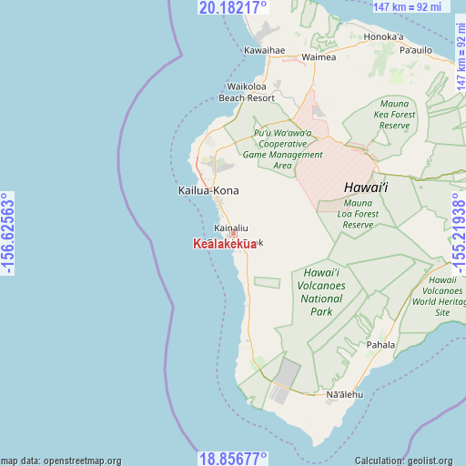
Kealakekua GPS coordinates[2]
19° 31' 14.988" North, 155° 55' 21" West
| Map corner | latitude | longitude |
|---|---|---|
| Upper-left | 20.18217°, | -156.62563° |
| Center: | 19.52083°, | -155.9225° |
| Lower-right: | 18.85677°, | -155.21938° |
| Map W x H: | 147.4×147.4 km | = 91.6×91.6mi |
| max Lat: | 71.29058° ⇑99.9% North |
| Kealakekua: | 19.52083° |
| min Lat: | ⇓0.1% South 19.06759° |
| min Long | Kealakekua | max Long |
| -171.73463° | -155.9225° | -66.98998° |
| W 0.7%⇐ | ⇒99.3% E |
Elevation
Elevation of Kealakekua is 445 m = 1460 ft, and this is 150.2 m = 493 ft above average elevation for this country.
| Max E: |
3189 m = 10463 ft | 13.9% |
| Kealakekua | 445 m 1460 ft | |
| Avg. | 294.8 m = 967 ft | |
Min E: |
-60 m = -197 ft | 86.1% |
See also: United States elevation on elevation.city.
Geographical zone
Kealakekua is located in North Torrid zone (between Equator and Tropic of Cancer). Distance of this Northern Tropic circle is 435.4 km =270.5 mi to North.| Distance of | km | miles | from Kealakekua |
|---|---|---|---|
| North Pole | 7836.5 | 4869.4 | to North |
| Arctic Circle | 5230.7 | 3250.2 | to North |
| Tropic Cancer | 435.4 | 270.5 | to North |
| Equator | 2170.5 | 1348.7 | to South |


Nearby cities:
15 places around Kealakekua: (largest is in red/bold)
• Captain Cook
2.7 km =1.7 mi,  178°
178°
• Hawaiian Ocean View
52.9 km =32.9 mi,  161°
161°
• Honalo
3 km =1.9 mi,  340°
340°
• Honaunau-Napoopoo
9.4 km =5.8 mi,  139°
139°
• Honoka‘a
78.3 km =48.7 mi,  37°
37°
• Hōlualoa
11.3 km =7 mi,  346°
346°
• Kahaluu-Keauhou
7 km =4.3 mi,  324°
324°
• Kailua-Kona
15.5 km =9.6 mi,  328°
328°
• Kalaoa
23.9 km =14.9 mi, 344°
• Naalehu
61.9 km =38.5 mi, 144°
• Puako
50.8 km =31.6 mi,  10°
10°
• Pāhala
58.5 km =36.4 mi,  127°
127°
• Volcano
72.7 km =45.2 mi,  96°
96°
• Waikoloa
48.6 km =30.2 mi,  16°
16°
• Waimea
61.7 km =38.3 mi,  25°
25°
Sources, notices
• [Note1] Compared only with cities in United States existing in our database
• [Src1] Map data: © OpenStreetMap contributors (CC-BY-SA)
• [Src2] Other city data from geonames.org with taken over terms of usage.
• [Src3] Geographical zone / Annual Mean Temperature by Robert A. Rohde @ Wikipedia
