Honaunau-Napoopoo geodata
Honaunau-Napoopoo (Hawaii) is a populated place; located in United States in Pacific/Honolulu (GMT-10) time zone. With population of 2,567 people, there are 10463 cities with bigger population in this country. Compared to other cities in United States, 100% of cities are located further ↑North; 99.3% of cities are located further →East and 92.1% of cities have lower elevation than Honaunau-Napoopoo. Note1


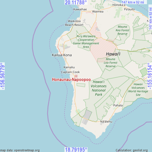
Honaunau-Napoopoo GPS coordinates[2]
19° 27' 22.572" North, 155° 51' 52.776" West
| Map corner | latitude | longitude |
|---|---|---|
| Upper-left | 20.11788°, | -156.56779° |
| Center: | 19.45627°, | -155.86466° |
| Lower-right: | 18.79195°, | -155.16154° |
| Map W x H: | 147.4×147.4 km | = 91.6×91.6mi |
| max Lat: | 71.29058° ⇑100% North |
| Honaunau-Napoopoo: | 19.45627° |
| min Lat: | ⇓0% South 19.06759° |
| min Long | Honaunau-Napoop | max Long |
| -171.73463° | -155.86466° | -66.98998° |
| W 0.7%⇐ | ⇒99.3% E |
Elevation
Elevation of Honaunau-Napoopoo is 809 m = 2654 ft, and this is 514.2 m = 1687 ft above average elevation for this country.
| Max E: |
3189 m = 10463 ft | 7.9% |
| Honaunau-Napoopoo | 809 m 2654 ft | |
| Avg. | 294.8 m = 967 ft | |
Min E: |
-60 m = -197 ft | 92.1% |
See also: United States elevation on elevation.city.
Geographical zone
Honaunau-Napoopoo is located in North Torrid zone (between Equator and Tropic of Cancer). Distance of this Northern Tropic circle is 442.6 km =275 mi to North.| Distance of | km | miles | from Honaunau-Napoopoo |
|---|---|---|---|
| North Pole | 7843.7 | 4873.8 | to North |
| Arctic Circle | 5237.8 | 3254.6 | to North |
| Tropic Cancer | 442.6 | 275 | to North |
| Equator | 2163.3 | 1344.2 | to South |


Nearby cities:
15 places around Honaunau-Napoopoo: (largest is in red/bold)
• Captain Cook
7.5 km =4.7 mi,  307°
307°
• Fern Forest
76.4 km =47.5 mi,  89°
89°
• Hawaiian Ocean View
44.4 km =27.6 mi,  166°
166°
• Honalo
12.3 km =7.6 mi,  324°
324°
• Hōlualoa
20.2 km =12.6 mi,  334°
334°
• Kahaluu-Keauhou
16.4 km =10.2 mi, 321°
• Kailua-Kona
24.8 km =15.4 mi, 325°
• Kalaoa
32.7 km =20.3 mi,  337°
337°
• Kealakekua
9.4 km =5.8 mi, 319°
• Naalehu
52.5 km =32.6 mi,  145°
145°
• Puako
57.2 km =35.5 mi,  2°
2°
• Pāhala
49.3 km =30.6 mi,  124°
124°
• Volcano
66.1 km =41.1 mi, 91°
• Waikoloa
54.3 km =33.7 mi,  8°
8°
• Waimea
66.2 km =41.1 mi,  17°
17°
Sources, notices
• [Note1] Compared only with cities in United States existing in our database
• [Src1] Map data: © OpenStreetMap contributors (CC-BY-SA)
• [Src2] Other city data from geonames.org with taken over terms of usage.
• [Src3] Geographical zone / Annual Mean Temperature by Robert A. Rohde @ Wikipedia
