Wahiawā geodata
Wahiawā (Hawaii) is a populated place; located in United States in Pacific/Honolulu (GMT-10) time zone. With population of 17,821 people, there are 2805 cities with bigger population in this country. Compared to other cities in United States, 99.5% of cities are located further ↑North; 99.6% of cities are located further →East and 70.9% of cities have lower elevation than Wahiawā. Note1


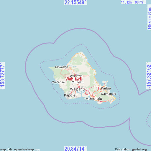
Wahiawā GPS coordinates[2]
21° 30' 10.044" North, 158° 1' 28.704" West
| Map corner | latitude | longitude |
|---|---|---|
| Upper-left | 22.15549°, | -158.72777° |
| Center: | 21.50279°, | -158.02464° |
| Lower-right: | 20.84714°, | -157.32152° |
| Map W x H: | 145.5×145.5 km | = 90.4×90.4mi |
| max Lat: | 71.29058° ⇑99.5% North |
| Wahiawā: | 21.50279° |
| min Lat: | ⇓0.5% South 19.06759° |
| min Long | Wahiawā | max Long |
| -171.73463° | -158.02464° | -66.98998° |
| W 0.4%⇐ | ⇒99.6% E |
Elevation
Elevation of Wahiawā is 290 m = 951 ft, and this is 4.8 m = 16 ft below average elevation for this country.
| Max E: |
3189 m = 10463 ft | 29.1% |
| Avg. | 294.8 m = 967 ft | |
| Wahiawā | 290 m = 951 ft | |
Min E: |
-60 m = -197 ft | 70.9% |
See also: United States elevation on elevation.city.
Geographical zone
Wahiawā is located in North Torrid zone (between Equator and Tropic of Cancer). Distance of this Northern Tropic circle is 215 km =133.6 mi to North.| Distance of | km | miles | from Wahiawā |
|---|---|---|---|
| North Pole | 7616.2 | 4732.5 | to North |
| Arctic Circle | 5010.3 | 3113.3 | to North |
| Tropic Cancer | 215 | 133.6 | to North |
| Equator | 2390.9 | 1485.6 | to South |


Nearby cities:
15 places around Wahiawā: (largest is in red/bold)
• Hale‘iwa
12.9 km =8 mi,  320°
320°
• Hau‘ula
16.7 km =10.4 mi,  45°
45°
• Mililani Town
6.4 km =4 mi,  157°
157°
• Mokulēia
15.8 km =9.8 mi,  302°
302°
• Pearl City
12.8 km =8 mi, 156°
• Royal Kunia
12.1 km =7.5 mi,  181°
181°
• Schofield Barracks
4.2 km =2.6 mi,  263°
263°
• Village Park
11.7 km =7.3 mi, 182°
• Waialua
13.8 km =8.6 mi,  306°
306°
• Waimalu
13.8 km =8.6 mi,  142°
142°
• Waipahu
13 km =8.1 mi,  172°
172°
• Waipio
9.8 km =6.1 mi, 164°
• Waipi‘o Acres
4.4 km =2.7 mi, 164°
• Whitmore Village
1.3 km =0.8 mi,  0°
0°
• ‘Aiea
16.4 km =10.2 mi, 144°
Sources, notices
• [Note1] Compared only with cities in United States existing in our database
• [Src1] Map data: © OpenStreetMap contributors (CC-BY-SA)
• [Src2] Other city data from geonames.org with taken over terms of usage.
• [Src3] Geographical zone / Annual Mean Temperature by Robert A. Rohde @ Wikipedia
