Schofield Barracks geodata
Schofield Barracks (Hawaii) is a populated place; located in United States in Pacific/Honolulu (GMT-10) time zone. With population of 16,370 people, there are 3003 cities with bigger population in this country. Compared to other cities in United States, 99.5% of cities are located further ↑North; 99.7% of cities are located further →East and 69.5% of cities have lower elevation than Schofield Barracks. Note1


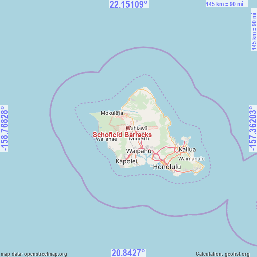
Schofield Barracks GPS coordinates[2]
21° 29' 54.132" North, 158° 3' 54.54" West
| Map corner | latitude | longitude |
|---|---|---|
| Upper-left | 22.15109°, | -158.76828° |
| Center: | 21.49837°, | -158.06515° |
| Lower-right: | 20.8427°, | -157.36203° |
| Map W x H: | 145.5×145.5 km | = 90.4×90.4mi |
| max Lat: | 71.29058° ⇑99.5% North |
| Schofield Barracks: | 21.49837° |
| min Lat: | ⇓0.5% South 19.06759° |
| min Long | Schofield Barra | max Long |
| -171.73463° | -158.06515° | -66.98998° |
| W 0.3%⇐ | ⇒99.7% E |
Elevation
Elevation of Schofield Barracks is 283 m = 928 ft, and this is 11.8 m = 39 ft below average elevation for this country.
| Max E: |
3189 m = 10463 ft | 30.5% |
| Avg. | 294.8 m = 967 ft | |
| Schofield Barracks | 283 m = 928 ft | |
Min E: |
-60 m = -197 ft | 69.5% |
See also: United States elevation on elevation.city.
Geographical zone
Schofield Barracks is located in North Torrid zone (between Equator and Tropic of Cancer). Distance of this Northern Tropic circle is 215.5 km =133.9 mi to North.| Distance of | km | miles | from Schofield Barracks |
|---|---|---|---|
| North Pole | 7616.7 | 4732.8 | to North |
| Arctic Circle | 5010.8 | 3113.6 | to North |
| Tropic Cancer | 215.5 | 133.9 | to North |
| Equator | 2390.4 | 1485.3 | to South |


Nearby cities:
15 places around Schofield Barracks: (largest is in red/bold)
• Hale‘iwa
11.2 km =7 mi,  339°
339°
• Mililani Town
8.5 km =5.3 mi,  129°
129°
• Mokulēia
12.8 km =8 mi,  314°
314°
• Mākaha Valley
14.1 km =8.8 mi,  259°
259°
• Mā‘ili
14.6 km =9.1 mi,  231°
231°
• Pearl City
14.6 km =9.1 mi,  140°
140°
• Royal Kunia
12.3 km =7.6 mi,  161°
161°
• Village Park
11.7 km =7.3 mi, 162°
• Wahiawā
4.2 km =2.6 mi,  83°
83°
• Waialua
11.1 km =6.9 mi,  321°
321°
• Waianae
14.2 km =8.8 mi,  241°
241°
• Waipahu
13.7 km =8.5 mi,  154°
154°
• Waipio
11.2 km =7 mi, 142°
• Waipi‘o Acres
6.5 km =4 mi,  124°
124°
• Whitmore Village
4.5 km =2.8 mi,  67°
67°
Sources, notices
• [Note1] Compared only with cities in United States existing in our database
• [Src1] Map data: © OpenStreetMap contributors (CC-BY-SA)
• [Src2] Other city data from geonames.org with taken over terms of usage.
• [Src3] Geographical zone / Annual Mean Temperature by Robert A. Rohde @ Wikipedia
