‘Āhuimanu geodata
‘Āhuimanu (Hawaii) is a populated place; located in United States in Pacific/Honolulu (GMT-10) time zone. With population of 8,810 people, there are 4885 cities with bigger population in this country. Compared to other cities in United States, 99.6% of cities are located further ↑North; 99.5% of cities are located further →East and 83.6% of cities have higher elevation than ‘Āhuimanu. Note1


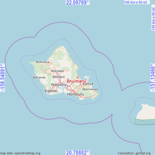
‘Āhuimanu GPS coordinates[2]
21° 26' 40.992" North, 157° 50' 16.008" West
| Map corner | latitude | longitude |
|---|---|---|
| Upper-left | 22.09769°, | -158.54091° |
| Center: | 21.44472°, | -157.83778° |
| Lower-right: | 20.78882°, | -157.13466° |
| Map W x H: | 145.5×145.5 km | = 90.4×90.4mi |
| max Lat: | 71.29058° ⇑99.6% North |
| ‘Āhuimanu: | 21.44472° |
| min Lat: | ⇓0.4% South 19.06759° |
| min Long | ‘Āhuimanu | max Long |
| -171.73463° | -157.83778° | -66.98998° |
| W 0.5%⇐ | ⇒99.5% E |
Elevation
Elevation of ‘Āhuimanu is 33 m = 108 ft, and this is 261.8 m = 859 ft below average elevation for this country.
| Max E: |
3189 m = 10463 ft | 83.6% |
| Avg. | 294.8 m = 967 ft | |
| ‘Āhuimanu | 33 m = 108 ft | |
Min E: |
-60 m = -197 ft | 16.4% |
See also: United States elevation on elevation.city.
Geographical zone
‘Āhuimanu is located in North Torrid zone (between Equator and Tropic of Cancer). Distance of this Northern Tropic circle is 221.5 km =137.6 mi to North.| Distance of | km | miles | from ‘Āhuimanu |
|---|---|---|---|
| North Pole | 7622.6 | 4736.5 | to North |
| Arctic Circle | 5016.7 | 3117.2 | to North |
| Tropic Cancer | 221.5 | 137.6 | to North |
| Equator | 2384.4 | 1481.6 | to South |


Nearby cities:
15 places around ‘Āhuimanu: (largest is in red/bold)
• He‘eia
2.7 km =1.7 mi,  125°
125°
• Hālawa
11.3 km =7 mi,  230°
230°
• Hālawa Heights
10.8 km =6.7 mi, 226°
• Kahalu‘u
1.6 km =1 mi,  334°
334°
• Kailua
11.1 km =6.9 mi,  115°
115°
• Kaneohe
6.4 km =4 mi,  141°
141°
• Ka‘a‘awa
12.3 km =7.6 mi,  353°
353°
• Marine Corps Base Hawaii - MCBH
9.1 km =5.7 mi,  90°
90°
• Maunawili
10.6 km =6.6 mi, 138°
• Pearl City
15.2 km =9.4 mi,  249°
249°
• Punaluu
15 km =9.3 mi,  343°
343°
• Punalu‘u
14.5 km =9 mi, 344°
• Waikane
5.9 km =3.7 mi, 345°
• Waimalu
11.8 km =7.3 mi, 247°
• ‘Aiea
12.1 km =7.5 mi, 234°
Sources, notices
• [Note1] Compared only with cities in United States existing in our database
• [Src1] Map data: © OpenStreetMap contributors (CC-BY-SA)
• [Src2] Other city data from geonames.org with taken over terms of usage.
• [Src3] Geographical zone / Annual Mean Temperature by Robert A. Rohde @ Wikipedia
