Kaneohe geodata
Kaneohe (Hawaii) is a populated place; located in United States in Pacific/Honolulu (GMT-10) time zone. With population of 34,597 people, there are 1422 cities with bigger population in this country. Compared to other cities in United States, 99.6% of cities are located further ↑North; 99.5% of cities are located further →East and 80.1% of cities have higher elevation than Kaneohe. Note1


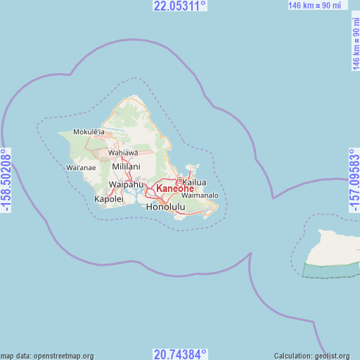
Kaneohe GPS coordinates[2]
21° 23' 59.784" North, 157° 47' 56.22" West
| Map corner | latitude | longitude |
|---|---|---|
| Upper-left | 22.05311°, | -158.50208° |
| Center: | 21.39994°, | -157.79895° |
| Lower-right: | 20.74384°, | -157.09583° |
| Map W x H: | 145.6×145.6 km | = 90.5×90.5mi |
| max Lat: | 71.29058° ⇑99.6% North |
| Kaneohe: | 21.39994° |
| min Lat: | ⇓0.4% South 19.06759° |
| min Long | Kaneohe | max Long |
| -171.73463° | -157.79895° | -66.98998° |
| W 0.5%⇐ | ⇒99.5% E |
Elevation
Elevation of Kaneohe is 46 m = 151 ft, and this is 248.8 m = 816 ft below average elevation for this country.
| Max E: |
3189 m = 10463 ft | 80.1% |
| Avg. | 294.8 m = 967 ft | |
| Kaneohe | 46 m = 151 ft | |
Min E: |
-60 m = -197 ft | 19.9% |
See also: United States elevation on elevation.city.
Geographical zone
Kaneohe is located in North Torrid zone (between Equator and Tropic of Cancer). Distance of this Northern Tropic circle is 226.5 km =140.7 mi to North.| Distance of | km | miles | from Kaneohe |
|---|---|---|---|
| North Pole | 7627.6 | 4739.6 | to North |
| Arctic Circle | 5021.7 | 3120.3 | to North |
| Tropic Cancer | 226.5 | 140.7 | to North |
| Equator | 2379.5 | 1478.6 | to South |


Nearby cities:
15 places around Kaneohe: (largest is in red/bold)
• East Honolulu
14.9 km =9.3 mi,  145°
145°
• He‘eia
3.8 km =2.4 mi,  332°
332°
• Honolulu
12 km =7.5 mi,  210°
210°
• Hālawa
12.9 km =8 mi,  259°
259°
• Hālawa Heights
12.1 km =7.5 mi, 258°
• Kahalu‘u
7.9 km =4.9 mi,  323°
323°
• Kailua
6.1 km =3.8 mi,  87°
87°
• Marine Corps Base Hawaii - MCBH
7 km =4.3 mi,  46°
46°
• Maunawili
4.2 km =2.6 mi,  135°
135°
• Waikane
12 km =7.5 mi, 332°
• Waimalu
15 km =9.3 mi,  272°
272°
• Waimanalo
9.8 km =6.1 mi,  127°
127°
• Waimānalo Beach
12.6 km =7.8 mi, 125°
• ‘Aiea
14.1 km =8.8 mi, 261°
• ‘Āhuimanu
6.4 km =4 mi, 321°
Sources, notices
• [Note1] Compared only with cities in United States existing in our database
• [Src1] Map data: © OpenStreetMap contributors (CC-BY-SA)
• [Src2] Other city data from geonames.org with taken over terms of usage.
• [Src3] Geographical zone / Annual Mean Temperature by Robert A. Rohde @ Wikipedia
