Kailua geodata
Kailua (Hawaii) is a populated place; located in United States in Pacific/Honolulu (GMT-10) time zone. With population of 38,635 people, there are 1252 cities with bigger population in this country. Compared to other cities in United States, 99.6% of cities are located further ↑North; 99.5% of cities are located further →East and 95.7% of cities have higher elevation than Kailua. Note1


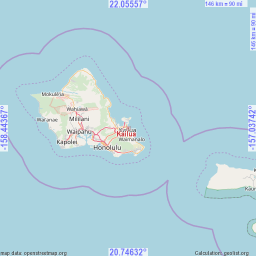
Kailua GPS coordinates[2]
21° 24' 8.676" North, 157° 44' 25.944" West
| Map corner | latitude | longitude |
|---|---|---|
| Upper-left | 22.05557°, | -158.44367° |
| Center: | 21.40241°, | -157.74054° |
| Lower-right: | 20.74632°, | -157.03742° |
| Map W x H: | 145.6×145.6 km | = 90.5×90.5mi |
| max Lat: | 71.29058° ⇑99.6% North |
| Kailua: | 21.40241° |
| min Lat: | ⇓0.4% South 19.06759° |
| min Long | Kailua | max Long |
| -171.73463° | -157.74054° | -66.98998° |
| W 0.5%⇐ | ⇒99.5% E |
Elevation
Elevation of Kailua is 8 m = 26 ft, and this is 286.8 m = 941 ft below average elevation for this country.
| Max E: |
3189 m = 10463 ft | 95.7% |
| Avg. | 294.8 m = 967 ft | |
| Kailua | 8 m = 26 ft | |
Min E: |
-60 m = -197 ft | 4.3% |
See also: United States elevation on elevation.city.
Geographical zone
Kailua is located in North Torrid zone (between Equator and Tropic of Cancer). Distance of this Northern Tropic circle is 226.2 km =140.6 mi to North.| Distance of | km | miles | from Kailua |
|---|---|---|---|
| North Pole | 7627.3 | 4739.4 | to North |
| Arctic Circle | 5021.4 | 3120.2 | to North |
| Tropic Cancer | 226.2 | 140.6 | to North |
| Equator | 2379.7 | 1478.7 | to South |


Nearby cities:
15 places around Kailua: (largest is in red/bold)
• East Honolulu
12.8 km =8 mi,  169°
169°
• He‘eia
8.4 km =5.2 mi,  291°
291°
• Honolulu
16.2 km =10.1 mi,  228°
228°
• Hālawa
18.9 km =11.7 mi,  262°
262°
• Hālawa Heights
18.1 km =11.2 mi, 261°
• Kahalu‘u
12.4 km =7.7 mi,  299°
299°
• Kaneohe
6.1 km =3.8 mi,  267°
267°
• Ka‘a‘awa
20.4 km =12.7 mi,  325°
325°
• Marine Corps Base Hawaii - MCBH
4.7 km =2.9 mi,  348°
348°
• Maunawili
4.5 km =2.8 mi,  223°
223°
• Waikane
15.6 km =9.7 mi,  312°
312°
• Waimanalo
6.5 km =4 mi,  164°
164°
• Waimānalo Beach
8.7 km =5.4 mi,  151°
151°
• ‘Aiea
20.1 km =12.5 mi, 263°
• ‘Āhuimanu
11.1 km =6.9 mi, 295°
Sources, notices
• [Note1] Compared only with cities in United States existing in our database
• [Src1] Map data: © OpenStreetMap contributors (CC-BY-SA)
• [Src2] Other city data from geonames.org with taken over terms of usage.
• [Src3] Geographical zone / Annual Mean Temperature by Robert A. Rohde @ Wikipedia
