Hālawa Heights geodata
Hālawa Heights (Hawaii) is a populated place; located in United States in Pacific/Honolulu (GMT-10) time zone. With population of 13,408 people, there are 3574 cities with bigger population in this country. Compared to other cities in United States, 99.6% of cities are located further ↑North; 99.6% of cities are located further →East and 74.6% of cities have higher elevation than Hālawa Heights. Note1


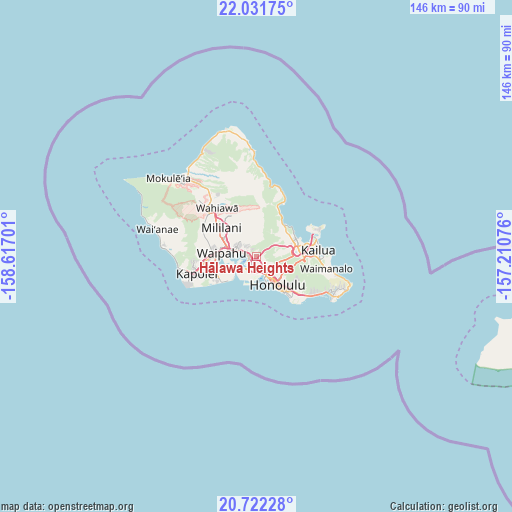
Hālawa Heights GPS coordinates[2]
21° 22' 42.528" North, 157° 54' 49.968" West
| Map corner | latitude | longitude |
|---|---|---|
| Upper-left | 22.03175°, | -158.61701° |
| Center: | 21.37848°, | -157.91388° |
| Lower-right: | 20.72228°, | -157.21076° |
| Map W x H: | 145.6×145.6 km | = 90.5×90.5mi |
| max Lat: | 71.29058° ⇑99.6% North |
| Hālawa Heights: | 21.37848° |
| min Lat: | ⇓0.4% South 19.06759° |
| min Long | Hālawa Heights | max Long |
| -171.73463° | -157.91388° | -66.98998° |
| W 0.4%⇐ | ⇒99.6% E |
Elevation
Elevation of Hālawa Heights is 74 m = 243 ft, and this is 220.8 m = 724 ft below average elevation for this country.
| Max E: |
3189 m = 10463 ft | 74.6% |
| Avg. | 294.8 m = 967 ft | |
| Hālawa Heights | 74 m = 243 ft | |
Min E: |
-60 m = -197 ft | 25.4% |
See also: United States elevation on elevation.city.
Geographical zone
Hālawa Heights is located in North Torrid zone (between Equator and Tropic of Cancer). Distance of this Northern Tropic circle is 228.9 km =142.2 mi to North.| Distance of | km | miles | from Hālawa Heights |
|---|---|---|---|
| North Pole | 7630 | 4741.1 | to North |
| Arctic Circle | 5024.1 | 3121.8 | to North |
| Tropic Cancer | 228.9 | 142.2 | to North |
| Equator | 2377.1 | 1477.1 | to South |


Nearby cities:
15 places around Hālawa Heights: (largest is in red/bold)
• He‘eia
11.7 km =7.3 mi,  60°
60°
• Hickam Field
6.5 km =4 mi,  228°
228°
• Honolulu
9.8 km =6.1 mi,  144°
144°
• Hālawa
0.8 km =0.5 mi,  277°
277°
• Iroquois Point
9.1 km =5.7 mi, 231°
• Kahalu‘u
11.4 km =7.1 mi,  39°
39°
• Mililani Town
12 km =7.5 mi,  311°
311°
• Pearl City
6.7 km =4.2 mi,  288°
288°
• Royal Kunia
11.8 km =7.3 mi, 278°
• Waimalu
4.2 km =2.6 mi, 313°
• Waipahu
9.9 km =6.2 mi, 275°
• Waipio
9.9 km =6.2 mi,  296°
296°
• ‘Aiea
2.1 km =1.3 mi, 281°
• ‘Ewa Beach
11.9 km =7.4 mi, 234°
• ‘Āhuimanu
10.8 km =6.7 mi,  46°
46°
Sources, notices
• [Note1] Compared only with cities in United States existing in our database
• [Src1] Map data: © OpenStreetMap contributors (CC-BY-SA)
• [Src2] Other city data from geonames.org with taken over terms of usage.
• [Src3] Geographical zone / Annual Mean Temperature by Robert A. Rohde @ Wikipedia
