Point MacKenzie geodata
Point MacKenzie (Alaska) is a populated place; located in United States in America/Anchorage (GMT-8) time zone. With population of 529 people, there are 20514 cities with bigger population in this country. Compared to other cities in United States, 99.7% of cities are located further ↓South; 99.1% of cities are located further →East and 77.1% of cities have higher elevation than Point MacKenzie. Note1


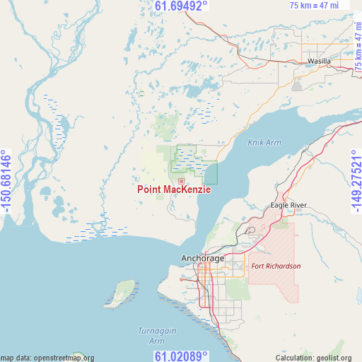
Point MacKenzie GPS coordinates[2]
61° 21' 34.992" North, 149° 58' 41.988" West
| Map corner | latitude | longitude |
|---|---|---|
| Upper-left | 61.69492°, | -150.68146° |
| Center: | 61.35972°, | -149.97833° |
| Lower-right: | 61.02089°, | -149.27521° |
| Map W x H: | 74.9×74.9 km | = 46.5×46.5mi |
| max Lat: | 71.29058° ⇑0.3% North |
| Point MacKenzie: | 61.35972° |
| min Lat: | ⇓99.7% South 19.06759° |
| min Long | Point MacKenzie | max Long |
| -171.73463° | -149.97833° | -66.98998° |
| W 0.9%⇐ | ⇒99.1% E |
Elevation
Elevation of Point MacKenzie is 60 m = 197 ft, and this is 234.8 m = 770 ft below average elevation for this country.
| Max E: |
3189 m = 10463 ft | 77.1% |
| Avg. | 294.8 m = 967 ft | |
| Point MacKenzie | 60 m = 197 ft | |
Min E: |
-60 m = -197 ft | 22.9% |
See also: United States elevation on elevation.city.
Geographical zone
Point MacKenzie is located in North temperate zone (between Tropic of Cancer and the Arctic Circle). Distance of this North polar circle is 578.6 km =359.5 mi to North.| Distance of | km | miles | from Point MacKenzie |
|---|---|---|---|
| North Pole | 3184.5 | 1978.8 | to North |
| Arctic Circle | 578.6 | 359.5 | to North |
| Tropic Cancer | 4216.6 | 2620.1 | to South |
| Equator | 6822.6 | 4239.4 | to South |


Nearby cities:
15 places around Point MacKenzie: (largest is in red/bold)
• Anchorage
16.3 km =10.1 mi,  165°
165°
• Big Lake
18 km =11.2 mi,  4°
4°
• Butte
54.2 km =33.7 mi,  67°
67°
• Eagle River
22.3 km =13.9 mi,  101°
101°
• Elmendorf Air Force Base
21.8 km =13.5 mi,  121°
121°
• Farm Loop
54.1 km =33.6 mi,  55°
55°
• Gateway
45.8 km =28.5 mi, 58°
• Houston
31.3 km =19.4 mi,  15°
15°
• Knik-Fairview
26.3 km =16.3 mi,  49°
49°
• Lakes
45 km =28 mi, 52°
• Meadow Lakes
35.6 km =22.1 mi,  34°
34°
• Palmer
53 km =32.9 mi, 59°
• Tanaina
41.7 km =25.9 mi,  44°
44°
• Wasilla
37.7 km =23.4 mi, 49°
• Willow
43.2 km =26.8 mi,  355°
355°
Sources, notices
• [Note1] Compared only with cities in United States existing in our database
• [Src1] Map data: © OpenStreetMap contributors (CC-BY-SA)
• [Src2] Other city data from geonames.org with taken over terms of usage.
• [Src3] Geographical zone / Annual Mean Temperature by Robert A. Rohde @ Wikipedia
