Knik-Fairview geodata
Knik-Fairview (Alaska) is a populated place; located in United States in America/Anchorage (GMT-8) time zone. With population of 14,923 people, there are 3254 cities with bigger population in this country. Compared to other cities in United States, 99.7% of cities are located further ↓South; 99% of cities are located further →East and 79% of cities have higher elevation than Knik-Fairview. Note1


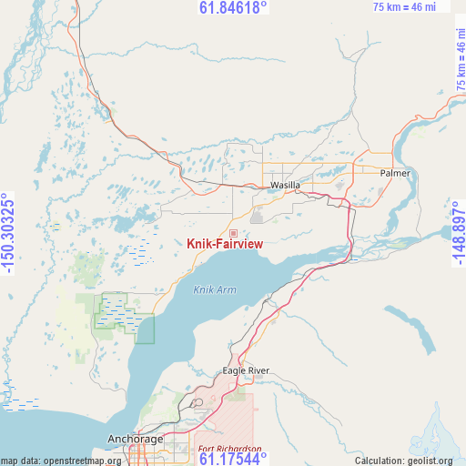
Knik-Fairview GPS coordinates[2]
61° 30' 45.432" North, 149° 36' 0.432" West
| Map corner | latitude | longitude |
|---|---|---|
| Upper-left | 61.84618°, | -150.30325° |
| Center: | 61.51262°, | -149.60012° |
| Lower-right: | 61.17544°, | -148.897° |
| Map W x H: | 74.6×74.6 km | = 46.4×46.4mi |
| max Lat: | 71.29058° ⇑0.3% North |
| Knik-Fairview: | 61.51262° |
| min Lat: | ⇓99.7% South 19.06759° |
| min Long | Knik-Fairview | max Long |
| -171.73463° | -149.60012° | -66.98998° |
| W 1%⇐ | ⇒99% E |
Elevation
Elevation of Knik-Fairview is 51 m = 167 ft, and this is 243.8 m = 800 ft below average elevation for this country.
| Max E: |
3189 m = 10463 ft | 79% |
| Avg. | 294.8 m = 967 ft | |
| Knik-Fairview | 51 m = 167 ft | |
Min E: |
-60 m = -197 ft | 21% |
See also: United States elevation on elevation.city.
Geographical zone
Knik-Fairview is located in North temperate zone (between Tropic of Cancer and the Arctic Circle). Distance of this North polar circle is 561.6 km =349 mi to North.| Distance of | km | miles | from Knik-Fairview |
|---|---|---|---|
| North Pole | 3167.5 | 1968.2 | to North |
| Arctic Circle | 561.6 | 349 | to North |
| Tropic Cancer | 4233.6 | 2630.6 | to South |
| Equator | 6839.6 | 4249.9 | to South |


Nearby cities:
15 places around Knik-Fairview: (largest is in red/bold)
• Big Lake
18.8 km =11.7 mi,  272°
272°
• Buffalo Soapstone
34.8 km =21.6 mi,  49°
49°
• Butte
30.2 km =18.8 mi,  83°
83°
• Eagle River
21.3 km =13.2 mi,  175°
175°
• Elmendorf Air Force Base
28.5 km =17.7 mi, 183°
• Farm Loop
28 km =17.4 mi,  59°
59°
• Fishhook
32.1 km =19.9 mi,  36°
36°
• Gateway
20.2 km =12.6 mi,  70°
70°
• Houston
17.4 km =10.8 mi,  318°
318°
• Lakes
18.7 km =11.6 mi, 55°
• Meadow Lakes
12.5 km =7.8 mi,  359°
359°
• Palmer
27.5 km =17.1 mi, 69°
• Point MacKenzie
26.3 km =16.3 mi,  229°
229°
• Tanaina
15.6 km =9.7 mi, 35°
• Wasilla
11.3 km =7 mi, 47°
Sources, notices
• [Note1] Compared only with cities in United States existing in our database
• [Src1] Map data: © OpenStreetMap contributors (CC-BY-SA)
• [Src2] Other city data from geonames.org with taken over terms of usage.
• [Src3] Geographical zone / Annual Mean Temperature by Robert A. Rohde @ Wikipedia
